You are here: Home > Network List > CN - Canadian National Seismograph Network Stations List
> Station A21 St-Andre, QC, CA > Earthquake Result Viewer
A21 St-Andre, QC, CA - Earthquake Result Viewer
| Earthquake location: |
Southern Peru |
| Earthquake latitude/longitude: |
-15.0/-70.4 |
| Earthquake time(UTC): |
2022/05/26 (146) 12:02:19 GMT |
| Earthquake Depth: |
212 km |
| Earthquake Magnitude: |
7.2 Mi |
| Earthquake Catalog/Contributor: |
NEIC PDE/at |
|
| Network: |
CN Canadian National Seismograph Network |
| Station: |
A21 St-Andre, QC, CA |
| Lat/Lon: |
47.70 N/69.69 W |
| Elevation: |
47 m |
|
| Distance: |
62.4 deg |
| Az: |
0.542 deg |
| Baz: |
180.775 deg |
| Ray Param: |
0.059586644 |
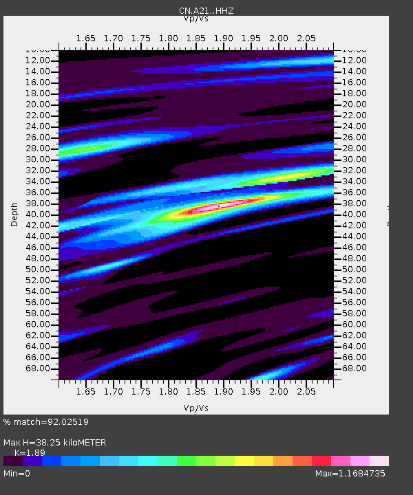
| Estimated Moho Depth: |
38.25 km |
| Estimated Crust Vp/Vs: |
1.89 |
| Assumed Crust Vp: |
6.419 km/s |
| Estimated Crust Vs: |
3.396 km/s |
| Estimated Crust Poisson's Ratio: |
0.31 |
|
| Radial Match: |
92.02519 % |
| Radial Bump: |
317 |
| Transverse Match: |
80.71879 % |
| Transverse Bump: |
400 |
| SOD ConfigId: |
27527651 |
| Insert Time: |
2022-06-09 12:13:08.334 +0000 |
| GWidth: |
2.5 |
| Max Bumps: |
400 |
| Tol: |
0.001 |
|

Signal To Noise
| Channel | StoN | STA | LTA |
| CN:A21: :HHZ:20220526T12:11:48.539978Z | 40.670963 | 5.0835165E-6 | 1.249913E-7 |
| CN:A21: :HHN:20220526T12:11:48.539978Z | 15.764792 | 2.1657916E-6 | 1.3738155E-7 |
| CN:A21: :HHE:20220526T12:11:48.539978Z | 3.2594795 | 4.3981046E-7 | 1.3493273E-7 |
| Arrivals |
| Ps | 5.5 SECOND |
| PpPs | 17 SECOND |
| PsPs/PpSs | 22 SECOND |


