You are here: Home > Network List > XM99 - Rio Grande Seismic Transect Stations List
> Station NM16 NewMexico16 > Earthquake Result Viewer
NM16 NewMexico16 - Earthquake Result Viewer
| Earthquake location: |
Santa Cruz Islands |
| Earthquake latitude/longitude: |
-12.5/166.9 |
| Earthquake time(UTC): |
2000/12/30 (365) 07:42:46 GMT |
| Earthquake Depth: |
221 km |
| Earthquake Magnitude: |
5.1 MB, 5.6 MW, 5.5 MW |
| Earthquake Catalog/Contributor: |
WHDF/NEIC |
|
| Network: |
XM Rio Grande Seismic Transect |
| Station: |
NM16 NewMexico16 |
| Lat/Lon: |
33.17 N/105.13 W |
| Elevation: |
1625 m |
|
| Distance: |
95.0 deg |
| Az: |
57.285 deg |
| Baz: |
258.471 deg |
| Ray Param: |
0.040716648 |
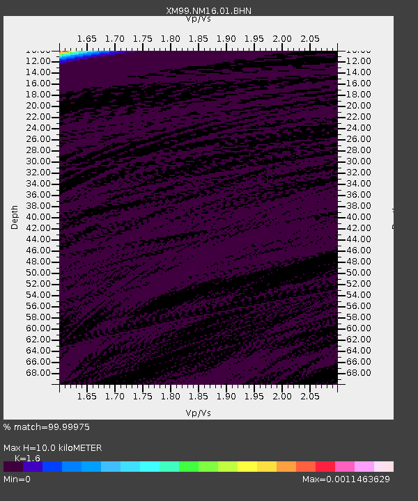
| Estimated Moho Depth: |
10.0 km |
| Estimated Crust Vp/Vs: |
1.60 |
| Assumed Crust Vp: |
6.232 km/s |
| Estimated Crust Vs: |
3.895 km/s |
| Estimated Crust Poisson's Ratio: |
0.18 |
|
| Radial Match: |
99.99975 % |
| Radial Bump: |
2 |
| Transverse Match: |
99.90149 % |
| Transverse Bump: |
26 |
| SOD ConfigId: |
16820 |
| Insert Time: |
2010-02-26 17:25:57.647 +0000 |
| GWidth: |
2.5 |
| Max Bumps: |
400 |
| Tol: |
0.001 |
|
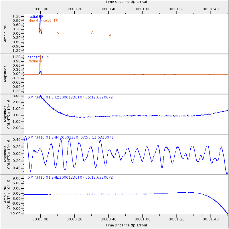
Signal To Noise
| Channel | StoN | STA | LTA |
| XM:NM16:01:BHN:20001230T07:55:12.632007Z | 0.52123934 | 1.5639775E-7 | 3.0004975E-7 |
| XM:NM16:01:BHE:20001230T07:55:12.632007Z | 0.916523 | 8.9205076E-7 | 9.732988E-7 |
| XM:NM16:01:BHZ:20001230T07:55:12.632007Z | 0.9158604 | 8.9313323E-7 | 9.751849E-7 |
| Arrivals |
| Ps | 1.0 SECOND |
| PpPs | 4.1 SECOND |
| PsPs/PpSs | 5.1 SECOND |


