You are here: Home > Network List > CN - Canadian National Seismograph Network Stations List
> Station TAHB Tahsis, BC, CA > Earthquake Result Viewer
TAHB Tahsis, BC, CA - Earthquake Result Viewer
| Earthquake location: |
Southern Peru |
| Earthquake latitude/longitude: |
-15.0/-70.4 |
| Earthquake time(UTC): |
2022/05/26 (146) 12:02:19 GMT |
| Earthquake Depth: |
212 km |
| Earthquake Magnitude: |
7.2 Mi |
| Earthquake Catalog/Contributor: |
NEIC PDE/at |
|
| Network: |
CN Canadian National Seismograph Network |
| Station: |
TAHB Tahsis, BC, CA |
| Lat/Lon: |
49.89 N/126.68 W |
| Elevation: |
455 m |
|
| Distance: |
81.3 deg |
| Az: |
327.033 deg |
| Baz: |
125.605 deg |
| Ray Param: |
0.0471333 |
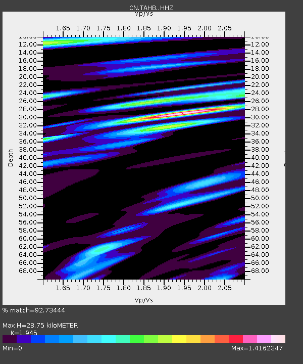
| Estimated Moho Depth: |
28.75 km |
| Estimated Crust Vp/Vs: |
1.95 |
| Assumed Crust Vp: |
6.24 km/s |
| Estimated Crust Vs: |
3.208 km/s |
| Estimated Crust Poisson's Ratio: |
0.32 |
|
| Radial Match: |
92.73444 % |
| Radial Bump: |
400 |
| Transverse Match: |
81.86825 % |
| Transverse Bump: |
400 |
| SOD ConfigId: |
27527651 |
| Insert Time: |
2022-06-09 12:15:38.360 +0000 |
| GWidth: |
2.5 |
| Max Bumps: |
400 |
| Tol: |
0.001 |
|

Signal To Noise
| Channel | StoN | STA | LTA |
| CN:TAHB: :HHZ:20220526T12:13:40.47998Z | 8.089584 | 1.5263014E-6 | 1.8867489E-7 |
| CN:TAHB: :HHN:20220526T12:13:40.47998Z | 1.5256804 | 3.0602422E-7 | 2.0058212E-7 |
| CN:TAHB: :HHE:20220526T12:13:40.47998Z | 3.5016685 | 6.320069E-7 | 1.8048736E-7 |
| Arrivals |
| Ps | 4.5 SECOND |
| PpPs | 13 SECOND |
| PsPs/PpSs | 18 SECOND |


