You are here: Home > Network List > XM99 - Rio Grande Seismic Transect Stations List
> Station NM16 NewMexico16 > Earthquake Result Viewer
NM16 NewMexico16 - Earthquake Result Viewer
| Earthquake location: |
Fiji Islands Region |
| Earthquake latitude/longitude: |
-21.3/-179.1 |
| Earthquake time(UTC): |
2000/12/25 (360) 05:11:58 GMT |
| Earthquake Depth: |
645 km |
| Earthquake Magnitude: |
5.3 MB, 5.7 MW, 5.7 MW |
| Earthquake Catalog/Contributor: |
WHDF/NEIC |
|
| Network: |
XM Rio Grande Seismic Transect |
| Station: |
NM16 NewMexico16 |
| Lat/Lon: |
33.17 N/105.13 W |
| Elevation: |
1625 m |
|
| Distance: |
88.9 deg |
| Az: |
53.74 deg |
| Baz: |
243.735 deg |
| Ray Param: |
0.041600775 |
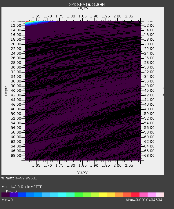
| Estimated Moho Depth: |
10.0 km |
| Estimated Crust Vp/Vs: |
1.60 |
| Assumed Crust Vp: |
6.232 km/s |
| Estimated Crust Vs: |
3.895 km/s |
| Estimated Crust Poisson's Ratio: |
0.18 |
|
| Radial Match: |
99.99581 % |
| Radial Bump: |
2 |
| Transverse Match: |
99.934326 % |
| Transverse Bump: |
8 |
| SOD ConfigId: |
16820 |
| Insert Time: |
2010-02-26 17:25:58.480 +0000 |
| GWidth: |
2.5 |
| Max Bumps: |
400 |
| Tol: |
0.001 |
|
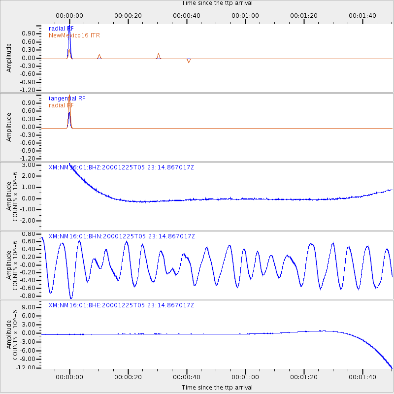
Signal To Noise
| Channel | StoN | STA | LTA |
| XM:NM16:01:BHN:20001225T05:23:14.867017Z | 1.4940602 | 5.1732263E-7 | 3.4625288E-7 |
| XM:NM16:01:BHE:20001225T05:23:14.867017Z | 0.8987834 | 8.791568E-7 | 9.781631E-7 |
| XM:NM16:01:BHZ:20001225T05:23:14.867017Z | 0.8989592 | 8.808529E-7 | 9.798586E-7 |
| Arrivals |
| Ps | 1.0 SECOND |
| PpPs | 4.1 SECOND |
| PsPs/PpSs | 5.1 SECOND |


