You are here: Home > Network List > CO - South Carolina Seismic Network Stations List
> Station PAULI CO:PAULI > Earthquake Result Viewer
PAULI CO:PAULI - Earthquake Result Viewer
| Earthquake location: |
Southern Peru |
| Earthquake latitude/longitude: |
-15.0/-70.4 |
| Earthquake time(UTC): |
2022/05/26 (146) 12:02:19 GMT |
| Earthquake Depth: |
212 km |
| Earthquake Magnitude: |
7.2 Mi |
| Earthquake Catalog/Contributor: |
NEIC PDE/at |
|
| Network: |
CO South Carolina Seismic Network |
| Station: |
PAULI CO:PAULI |
| Lat/Lon: |
34.82 N/81.81 W |
| Elevation: |
179 m |
|
| Distance: |
50.7 deg |
| Az: |
347.857 deg |
| Baz: |
165.696 deg |
| Ray Param: |
0.06710831 |
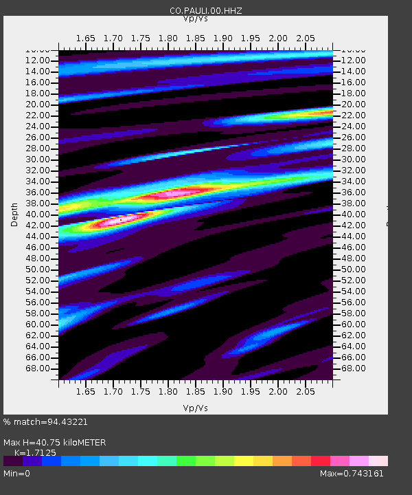
| Estimated Moho Depth: |
40.75 km |
| Estimated Crust Vp/Vs: |
1.71 |
| Assumed Crust Vp: |
6.419 km/s |
| Estimated Crust Vs: |
3.748 km/s |
| Estimated Crust Poisson's Ratio: |
0.24 |
|
| Radial Match: |
94.43221 % |
| Radial Bump: |
348 |
| Transverse Match: |
72.02905 % |
| Transverse Bump: |
400 |
| SOD ConfigId: |
27527651 |
| Insert Time: |
2022-06-09 12:16:28.970 +0000 |
| GWidth: |
2.5 |
| Max Bumps: |
400 |
| Tol: |
0.001 |
|

Signal To Noise
| Channel | StoN | STA | LTA |
| CO:PAULI:00:HHZ:20220526T12:10:26.369995Z | 60.90633 | 6.8955615E-6 | 1.1321585E-7 |
| CO:PAULI:00:HHN:20220526T12:10:26.369995Z | 21.776413 | 3.6971908E-6 | 1.6977961E-7 |
| CO:PAULI:00:HHE:20220526T12:10:26.369995Z | 6.8220663 | 1.2695675E-6 | 1.8609721E-7 |
| Arrivals |
| Ps | 4.8 SECOND |
| PpPs | 16 SECOND |
| PsPs/PpSs | 21 SECOND |


