You are here: Home > Network List > G - GEOSCOPE Stations List
> Station UNM Unam,Mexico > Earthquake Result Viewer
UNM Unam,Mexico - Earthquake Result Viewer
| Earthquake location: |
Southern Peru |
| Earthquake latitude/longitude: |
-15.0/-70.4 |
| Earthquake time(UTC): |
2022/05/26 (146) 12:02:19 GMT |
| Earthquake Depth: |
212 km |
| Earthquake Magnitude: |
7.2 Mi |
| Earthquake Catalog/Contributor: |
NEIC PDE/at |
|
| Network: |
G GEOSCOPE |
| Station: |
UNM Unam,Mexico |
| Lat/Lon: |
19.33 N/99.18 W |
| Elevation: |
2280 m |
|
| Distance: |
44.3 deg |
| Az: |
319.423 deg |
| Baz: |
138.268 deg |
| Ray Param: |
0.071152456 |
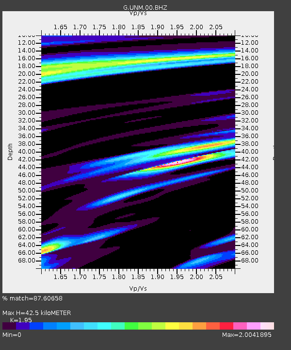
| Estimated Moho Depth: |
42.5 km |
| Estimated Crust Vp/Vs: |
1.95 |
| Assumed Crust Vp: |
6.597 km/s |
| Estimated Crust Vs: |
3.383 km/s |
| Estimated Crust Poisson's Ratio: |
0.32 |
|
| Radial Match: |
87.60658 % |
| Radial Bump: |
400 |
| Transverse Match: |
71.62879 % |
| Transverse Bump: |
400 |
| SOD ConfigId: |
27527651 |
| Insert Time: |
2022-06-09 12:17:42.846 +0000 |
| GWidth: |
2.5 |
| Max Bumps: |
400 |
| Tol: |
0.001 |
|

Signal To Noise
| Channel | StoN | STA | LTA |
| G:UNM:00:BHZ:20220526T12:09:37.450012Z | 3.7581499 | 2.0466168E-6 | 5.445809E-7 |
| G:UNM:00:BHN:20220526T12:09:37.450012Z | 0.97733283 | 7.8819704E-7 | 8.064776E-7 |
| G:UNM:00:BHE:20220526T12:09:37.450012Z | 1.101006 | 6.714691E-7 | 6.0986866E-7 |
| Arrivals |
| Ps | 6.5 SECOND |
| PpPs | 18 SECOND |
| PsPs/PpSs | 24 SECOND |


