You are here: Home > Network List > US - United States National Seismic Network Stations List
> Station CBKS Cedar Bluff, Kansas, USA > Earthquake Result Viewer
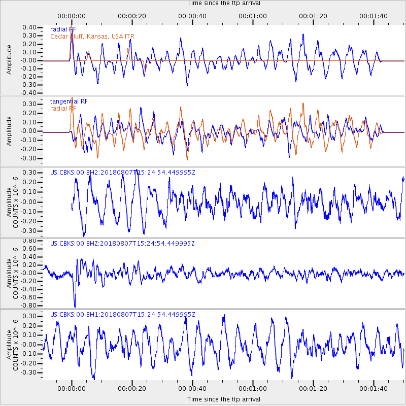
CBKS Cedar Bluff, Kansas, USA - Earthquake Result Viewer
*The percent match for this event was below the threshold and hence no stack was calculated.
| Earthquake location: |
Off East Coast Of Honshu, Japan |
| Earthquake latitude/longitude: |
37.9/144.1 |
| Earthquake time(UTC): |
2018/08/07 (219) 15:12:57 GMT |
| Earthquake Depth: |
12 km |
| Earthquake Magnitude: |
5.6 Mww |
| Earthquake Catalog/Contributor: |
NEIC PDE/us |
|
| Network: |
US United States National Seismic Network |
| Station: |
CBKS Cedar Bluff, Kansas, USA |
| Lat/Lon: |
38.81 N/99.74 W |
| Elevation: |
677 m |
|
| Distance: |
83.8 deg |
| Az: |
44.841 deg |
| Baz: |
314.419 deg |
| Ray Param: |
$rayparam |
*The percent match for this event was below the threshold and hence was not used in the summary stack. |
|
| Radial Match: |
64.84689 % |
| Radial Bump: |
400 |
| Transverse Match: |
66.88372 % |
| Transverse Bump: |
400 |
| SOD ConfigId: |
2778632 |
| Insert Time: |
2018-08-21 15:20:13.916 +0000 |
| GWidth: |
2.5 |
| Max Bumps: |
400 |
| Tol: |
0.001 |
|
Signal To Noise
| Channel | StoN | STA | LTA |
| US:CBKS:00:BHZ:20180807T15:24:54.449995Z | 3.8602242 | 3.1824942E-7 | 8.244324E-8 |
| US:CBKS:00:BH1:20180807T15:24:54.449995Z | 1.4586772 | 1.192677E-7 | 8.1764284E-8 |
| US:CBKS:00:BH2:20180807T15:24:54.449995Z | 0.76094985 | 1.3537358E-7 | 1.779008E-7 |
| Arrivals |
| Ps | |
| PpPs | |
| PsPs/PpSs | |


