You are here: Home > Network List > GM - US Geological Survey Networks Stations List
> Station NMP31 New Mexico Permian - Site# W3S1 > Earthquake Result Viewer
NMP31 New Mexico Permian - Site# W3S1 - Earthquake Result Viewer
| Earthquake location: |
Southern Peru |
| Earthquake latitude/longitude: |
-15.0/-70.4 |
| Earthquake time(UTC): |
2022/05/26 (146) 12:02:19 GMT |
| Earthquake Depth: |
212 km |
| Earthquake Magnitude: |
7.2 Mi |
| Earthquake Catalog/Contributor: |
NEIC PDE/at |
|
| Network: |
GM US Geological Survey Networks |
| Station: |
NMP31 New Mexico Permian - Site# W3S1 |
| Lat/Lon: |
32.04 N/103.73 W |
| Elevation: |
973 m |
|
| Distance: |
56.6 deg |
| Az: |
326.027 deg |
| Baz: |
140.519 deg |
| Ray Param: |
0.06330498 |
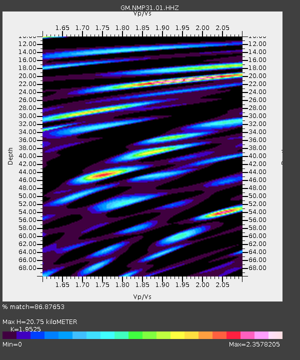
| Estimated Moho Depth: |
20.75 km |
| Estimated Crust Vp/Vs: |
1.95 |
| Assumed Crust Vp: |
6.129 km/s |
| Estimated Crust Vs: |
3.139 km/s |
| Estimated Crust Poisson's Ratio: |
0.32 |
|
| Radial Match: |
86.87653 % |
| Radial Bump: |
400 |
| Transverse Match: |
80.44281 % |
| Transverse Bump: |
400 |
| SOD ConfigId: |
27527651 |
| Insert Time: |
2022-06-09 12:18:52.491 +0000 |
| GWidth: |
2.5 |
| Max Bumps: |
400 |
| Tol: |
0.001 |
|

Signal To Noise
| Channel | StoN | STA | LTA |
| GM:NMP31:01:HHZ:20220526T12:11:09.155029Z | 45.1612 | 8.8705065E-6 | 1.9641874E-7 |
| GM:NMP31:01:HHN:20220526T12:11:09.155029Z | 4.0490656 | 1.8534004E-6 | 4.5773533E-7 |
| GM:NMP31:01:HHE:20220526T12:11:09.155029Z | 9.021568 | 2.0009422E-6 | 2.2179539E-7 |
| Arrivals |
| Ps | 3.4 SECOND |
| PpPs | 9.6 SECOND |
| PsPs/PpSs | 13 SECOND |


