You are here: Home > Network List > US - United States National Seismic Network Stations List
> Station DGMT Dagmar, Montana, USA > Earthquake Result Viewer
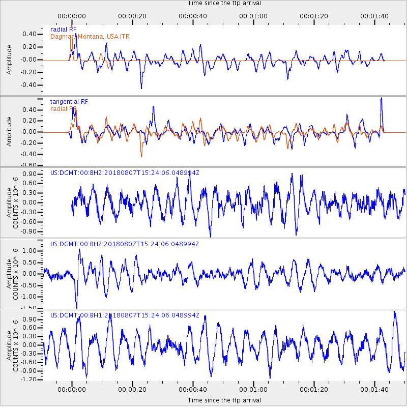
DGMT Dagmar, Montana, USA - Earthquake Result Viewer
*The percent match for this event was below the threshold and hence no stack was calculated.
| Earthquake location: |
Off East Coast Of Honshu, Japan |
| Earthquake latitude/longitude: |
37.9/144.1 |
| Earthquake time(UTC): |
2018/08/07 (219) 15:12:57 GMT |
| Earthquake Depth: |
12 km |
| Earthquake Magnitude: |
5.6 Mww |
| Earthquake Catalog/Contributor: |
NEIC PDE/us |
|
| Network: |
US United States National Seismic Network |
| Station: |
DGMT Dagmar, Montana, USA |
| Lat/Lon: |
48.47 N/104.20 W |
| Elevation: |
0.0 m |
|
| Distance: |
74.9 deg |
| Az: |
39.822 deg |
| Baz: |
310.406 deg |
| Ray Param: |
$rayparam |
*The percent match for this event was below the threshold and hence was not used in the summary stack. |
|
| Radial Match: |
56.23552 % |
| Radial Bump: |
400 |
| Transverse Match: |
56.352245 % |
| Transverse Bump: |
400 |
| SOD ConfigId: |
2778632 |
| Insert Time: |
2018-08-21 15:20:20.064 +0000 |
| GWidth: |
2.5 |
| Max Bumps: |
400 |
| Tol: |
0.001 |
|
Signal To Noise
| Channel | StoN | STA | LTA |
| US:DGMT:00:BHZ:20180807T15:24:06.048994Z | 3.7031095 | 6.0617185E-7 | 1.6369266E-7 |
| US:DGMT:00:BH1:20180807T15:24:06.048994Z | 1.9441237 | 6.750907E-7 | 3.4724675E-7 |
| US:DGMT:00:BH2:20180807T15:24:06.048994Z | 1.2593869 | 3.4352317E-7 | 2.7277017E-7 |
| Arrivals |
| Ps | |
| PpPs | |
| PsPs/PpSs | |


