NM16 NewMexico16 - Earthquake Result Viewer
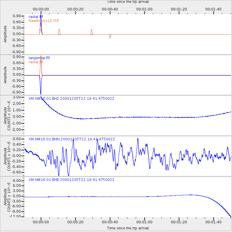
Earthquake location: Fox Islands, Aleutian Islands
Earthquake latitude/longitude: 52.6/-167.8
Earthquake time(UTC): 2000/12/05 (340) 22:11:34 GMT
Earthquake Depth: 33 km
Earthquake Magnitude: 5.6 MB, 5.6 MS, 5.9 MW, 5.4 ML
Earthquake Catalog/Contributor: WHDF/NEIC
Network: XM Rio Grande Seismic Transect
Station: NM16 NewMexico16
Lat/Lon: 33.17 N/105.13 W
Elevation: 1625 m
Distance: 48.2 deg
Az: 87.861 deg
Baz: 313.353 deg
Ray Param: 0.06942559
Estimated Moho Depth: 10.0 km
Estimated Crust Vp/Vs: 1.60
Assumed Crust Vp: 6.232 km/s
Estimated Crust Vs: 3.895 km/s
Estimated Crust Poisson's Ratio: 0.18
Radial Match: 99.993835 %
Radial Bump: 2
Transverse Match: 99.99278 %
Transverse Bump: 2
SOD ConfigId: 16820
Insert Time: 2010-02-26 17:26:00.414 +0000
GWidth: 2.5
Max Bumps: 400
Tol: 0.001

Signal To Noise

ChannelStoNSTALTA
XM:NM16:01:BHN:20001205T22:19:41.475002Z2.2276052.6711345E-71.199106E-7
XM:NM16:01:BHE:20001205T22:19:41.475002Z0.91052038.8317853E-79.699712E-7
XM:NM16:01:BHZ:20001205T22:19:41.475002Z0.910552448.846233E-79.715237E-7
Arrivals
Ps1.0 SECOND
PpPs3.9 SECOND
PsPs/PpSs4.9 SECOND