You are here: Home > Network List > GM - US Geological Survey Networks Stations List
> Station NMP23 New Mexico Permian - Site# W2S3 > Earthquake Result Viewer
NMP23 New Mexico Permian - Site# W2S3 - Earthquake Result Viewer
| Earthquake location: |
Southern Peru |
| Earthquake latitude/longitude: |
-15.0/-70.4 |
| Earthquake time(UTC): |
2022/05/26 (146) 12:02:19 GMT |
| Earthquake Depth: |
212 km |
| Earthquake Magnitude: |
7.2 Mi |
| Earthquake Catalog/Contributor: |
NEIC PDE/at |
|
| Network: |
GM US Geological Survey Networks |
| Station: |
NMP23 New Mexico Permian - Site# W2S3 |
| Lat/Lon: |
32.17 N/103.80 W |
| Elevation: |
1050 m |
|
| Distance: |
56.8 deg |
| Az: |
326.073 deg |
| Baz: |
140.509 deg |
| Ray Param: |
0.06321795 |
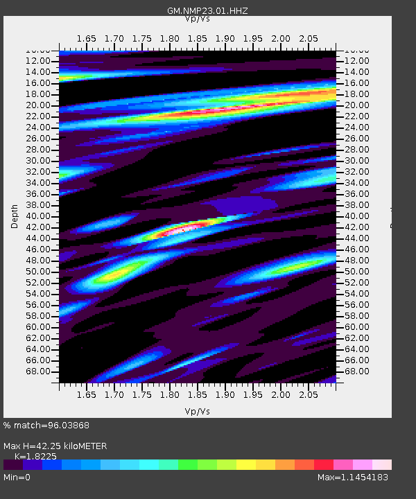
| Estimated Moho Depth: |
42.25 km |
| Estimated Crust Vp/Vs: |
1.82 |
| Assumed Crust Vp: |
6.129 km/s |
| Estimated Crust Vs: |
3.363 km/s |
| Estimated Crust Poisson's Ratio: |
0.28 |
|
| Radial Match: |
96.03868 % |
| Radial Bump: |
400 |
| Transverse Match: |
87.445625 % |
| Transverse Bump: |
400 |
| SOD ConfigId: |
27527651 |
| Insert Time: |
2022-06-09 12:19:04.990 +0000 |
| GWidth: |
2.5 |
| Max Bumps: |
400 |
| Tol: |
0.001 |
|

Signal To Noise
| Channel | StoN | STA | LTA |
| GM:NMP23:01:HHZ:20220526T12:11:10.125Z | 82.701126 | 1.0181739E-5 | 1.2311487E-7 |
| GM:NMP23:01:HHN:20220526T12:11:10.125Z | 13.0046015 | 2.5800052E-6 | 1.9839172E-7 |
| GM:NMP23:01:HHE:20220526T12:11:10.125Z | 35.422432 | 3.5161975E-6 | 9.92647E-8 |
| Arrivals |
| Ps | 5.9 SECOND |
| PpPs | 19 SECOND |
| PsPs/PpSs | 25 SECOND |


