You are here: Home > Network List > GS - US Geological Survey Networks Stations List
> Station PR01 PR01, Lajas > Earthquake Result Viewer
PR01 PR01, Lajas - Earthquake Result Viewer
| Earthquake location: |
Southern Peru |
| Earthquake latitude/longitude: |
-15.0/-70.4 |
| Earthquake time(UTC): |
2022/05/26 (146) 12:02:19 GMT |
| Earthquake Depth: |
212 km |
| Earthquake Magnitude: |
7.2 Mi |
| Earthquake Catalog/Contributor: |
NEIC PDE/at |
|
| Network: |
GS US Geological Survey Networks |
| Station: |
PR01 PR01, Lajas |
| Lat/Lon: |
18.03 N/67.07 W |
| Elevation: |
33 m |
|
| Distance: |
33.0 deg |
| Az: |
5.83 deg |
| Baz: |
185.921 deg |
| Ray Param: |
0.07772532 |
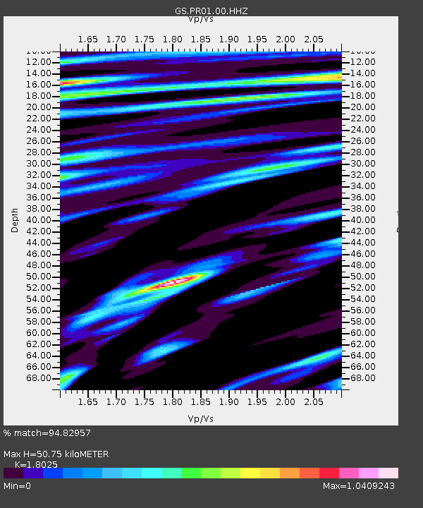
| Estimated Moho Depth: |
50.75 km |
| Estimated Crust Vp/Vs: |
1.80 |
| Assumed Crust Vp: |
5.14 km/s |
| Estimated Crust Vs: |
2.852 km/s |
| Estimated Crust Poisson's Ratio: |
0.28 |
|
| Radial Match: |
94.82957 % |
| Radial Bump: |
314 |
| Transverse Match: |
87.96569 % |
| Transverse Bump: |
400 |
| SOD ConfigId: |
27527651 |
| Insert Time: |
2022-06-09 12:19:40.092 +0000 |
| GWidth: |
2.5 |
| Max Bumps: |
400 |
| Tol: |
0.001 |
|

Signal To Noise
| Channel | StoN | STA | LTA |
| GS:PR01:00:HHZ:20220526T12:08:03.449005Z | 152.40512 | 4.4938897E-5 | 2.9486475E-7 |
| GS:PR01:00:HH1:20220526T12:08:03.449005Z | 102.50169 | 2.4571058E-5 | 2.3971367E-7 |
| GS:PR01:00:HH2:20220526T12:08:03.449005Z | 16.956766 | 4.432452E-6 | 2.6139725E-7 |
| Arrivals |
| Ps | 8.3 SECOND |
| PpPs | 26 SECOND |
| PsPs/PpSs | 35 SECOND |


