You are here: Home > Network List > GS - US Geological Survey Networks Stations List
> Station PR03 PR03, Alturas Sabaneras > Earthquake Result Viewer
PR03 PR03, Alturas Sabaneras - Earthquake Result Viewer
| Earthquake location: |
Southern Peru |
| Earthquake latitude/longitude: |
-15.0/-70.4 |
| Earthquake time(UTC): |
2022/05/26 (146) 12:02:19 GMT |
| Earthquake Depth: |
212 km |
| Earthquake Magnitude: |
7.2 Mi |
| Earthquake Catalog/Contributor: |
NEIC PDE/at |
|
| Network: |
GS US Geological Survey Networks |
| Station: |
PR03 PR03, Alturas Sabaneras |
| Lat/Lon: |
18.07 N/66.94 W |
| Elevation: |
113 m |
|
| Distance: |
33.0 deg |
| Az: |
6.049 deg |
| Baz: |
186.145 deg |
| Ray Param: |
0.07770357 |
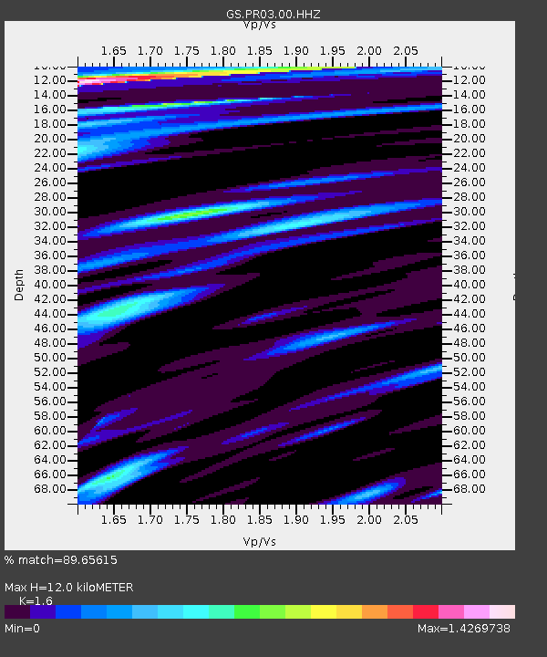
| Estimated Moho Depth: |
12.0 km |
| Estimated Crust Vp/Vs: |
1.60 |
| Assumed Crust Vp: |
5.14 km/s |
| Estimated Crust Vs: |
3.212 km/s |
| Estimated Crust Poisson's Ratio: |
0.18 |
|
| Radial Match: |
89.65615 % |
| Radial Bump: |
400 |
| Transverse Match: |
76.986755 % |
| Transverse Bump: |
400 |
| SOD ConfigId: |
27527651 |
| Insert Time: |
2022-06-09 12:19:41.371 +0000 |
| GWidth: |
2.5 |
| Max Bumps: |
400 |
| Tol: |
0.001 |
|

Signal To Noise
| Channel | StoN | STA | LTA |
| GS:PR03:00:HHZ:20220526T12:08:03.82901Z | 129.11906 | 4.0556966E-5 | 3.1410516E-7 |
| GS:PR03:00:HH1:20220526T12:08:03.82901Z | 59.870865 | 1.49196585E-5 | 2.491973E-7 |
| GS:PR03:00:HH2:20220526T12:08:03.82901Z | 12.511984 | 3.0635986E-6 | 2.4485314E-7 |
| Arrivals |
| Ps | 1.5 SECOND |
| PpPs | 5.8 SECOND |
| PsPs/PpSs | 7.2 SECOND |


