You are here: Home > Network List > IU - Global Seismograph Network (GSN - IRIS/USGS) Stations List
> Station RSSD Black Hills, South Dakota, USA > Earthquake Result Viewer
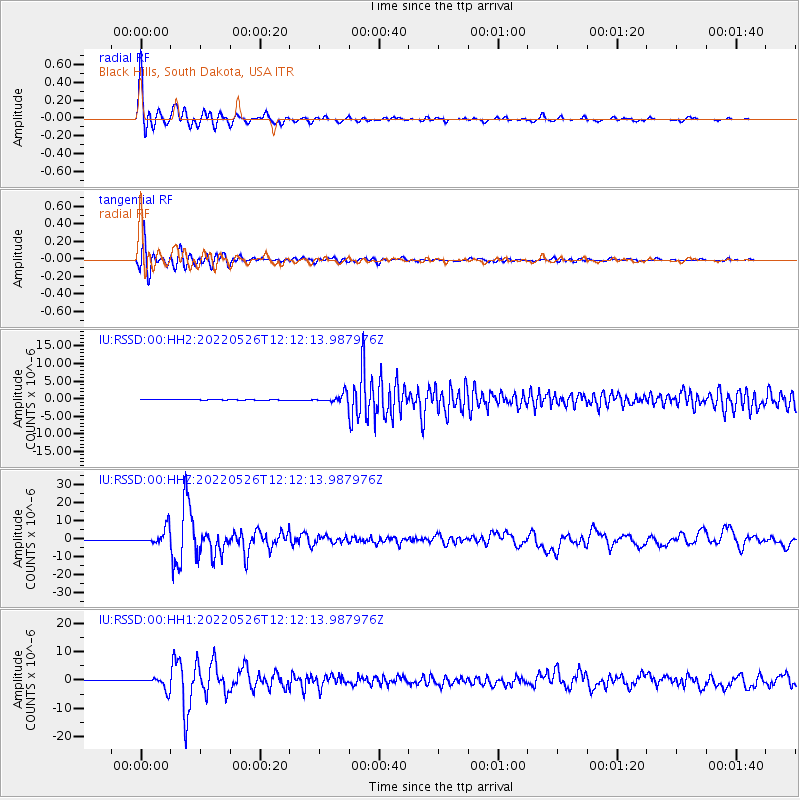
RSSD Black Hills, South Dakota, USA - Earthquake Result Viewer
*The percent match for this event was below the threshold and hence no stack was calculated.
| Earthquake location: |
Southern Peru |
| Earthquake latitude/longitude: |
-15.0/-70.4 |
| Earthquake time(UTC): |
2022/05/26 (146) 12:02:19 GMT |
| Earthquake Depth: |
212 km |
| Earthquake Magnitude: |
7.2 Mi |
| Earthquake Catalog/Contributor: |
NEIC PDE/at |
|
| Network: |
IU Global Seismograph Network (GSN - IRIS/USGS) |
| Station: |
RSSD Black Hills, South Dakota, USA |
| Lat/Lon: |
44.12 N/104.04 W |
| Elevation: |
2090 m |
|
| Distance: |
66.4 deg |
| Az: |
334.184 deg |
| Baz: |
144.245 deg |
| Ray Param: |
$rayparam |
*The percent match for this event was below the threshold and hence was not used in the summary stack. |
|
| Radial Match: |
97.27585 % |
| Radial Bump: |
362 |
| Transverse Match: |
91.36712 % |
| Transverse Bump: |
400 |
| SOD ConfigId: |
27527651 |
| Insert Time: |
2022-06-09 12:20:46.325 +0000 |
| GWidth: |
2.5 |
| Max Bumps: |
400 |
| Tol: |
0.001 |
|
Signal To Noise
| Channel | StoN | STA | LTA |
| IU:RSSD:00:HHZ:20220526T12:12:13.987976Z | 55.30405 | 4.4143326E-6 | 7.981934E-8 |
| IU:RSSD:00:HH1:20220526T12:12:13.987976Z | 37.62628 | 2.1681308E-6 | 5.7622774E-8 |
| IU:RSSD:00:HH2:20220526T12:12:13.987976Z | 30.551052 | 1.2440659E-6 | 4.0720884E-8 |
| Arrivals |
| Ps | |
| PpPs | |
| PsPs/PpSs | |


