You are here: Home > Network List > IW - Intermountain West Stations List
> Station MOOW Moose Ponds, Wyoming, USA > Earthquake Result Viewer
MOOW Moose Ponds, Wyoming, USA - Earthquake Result Viewer
| Earthquake location: |
Southern Peru |
| Earthquake latitude/longitude: |
-15.0/-70.4 |
| Earthquake time(UTC): |
2022/05/26 (146) 12:02:19 GMT |
| Earthquake Depth: |
212 km |
| Earthquake Magnitude: |
7.2 Mi |
| Earthquake Catalog/Contributor: |
NEIC PDE/at |
|
| Network: |
IW Intermountain West |
| Station: |
MOOW Moose Ponds, Wyoming, USA |
| Lat/Lon: |
43.75 N/110.74 W |
| Elevation: |
2128 m |
|
| Distance: |
69.1 deg |
| Az: |
329.857 deg |
| Baz: |
137.963 deg |
| Ray Param: |
0.055266943 |
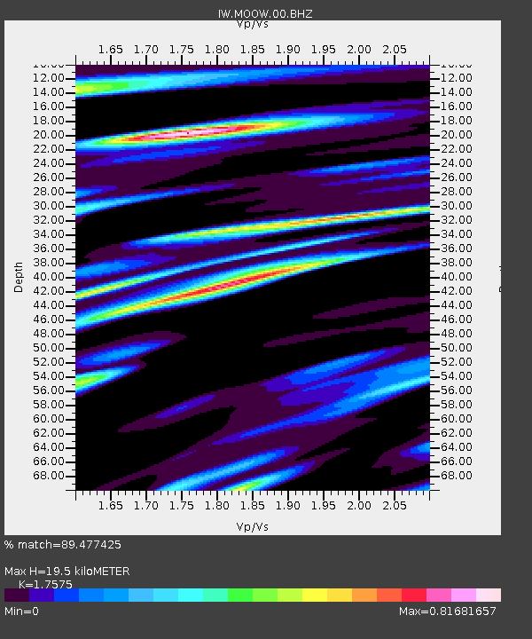
| Estimated Moho Depth: |
19.5 km |
| Estimated Crust Vp/Vs: |
1.76 |
| Assumed Crust Vp: |
6.207 km/s |
| Estimated Crust Vs: |
3.532 km/s |
| Estimated Crust Poisson's Ratio: |
0.26 |
|
| Radial Match: |
89.477425 % |
| Radial Bump: |
400 |
| Transverse Match: |
85.29875 % |
| Transverse Bump: |
400 |
| SOD ConfigId: |
27527651 |
| Insert Time: |
2022-06-09 12:21:07.346 +0000 |
| GWidth: |
2.5 |
| Max Bumps: |
400 |
| Tol: |
0.001 |
|
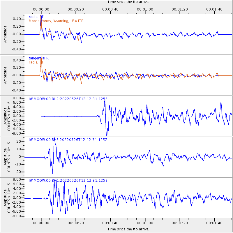
Signal To Noise
| Channel | StoN | STA | LTA |
| IW:MOOW:00:BHZ:20220526T12:12:31.125Z | 58.33703 | 3.3681943E-6 | 5.7736813E-8 |
| IW:MOOW:00:BH1:20220526T12:12:31.125Z | 28.021679 | 8.6786304E-7 | 3.0971126E-8 |
| IW:MOOW:00:BH2:20220526T12:12:31.125Z | 26.20624 | 9.213353E-7 | 3.5157097E-8 |
| Arrivals |
| Ps | 2.5 SECOND |
| PpPs | 8.4 SECOND |
| PsPs/PpSs | 11 SECOND |


