You are here: Home > Network List > XM99 - Rio Grande Seismic Transect Stations List
> Station NM16 NewMexico16 > Earthquake Result Viewer
NM16 NewMexico16 - Earthquake Result Viewer
| Earthquake location: |
Fiji Islands Region |
| Earthquake latitude/longitude: |
-21.3/-179.2 |
| Earthquake time(UTC): |
2000/11/13 (318) 23:17:28 GMT |
| Earthquake Depth: |
628 km |
| Earthquake Magnitude: |
5.1 MB, 5.6 MW |
| Earthquake Catalog/Contributor: |
WHDF/NEIC |
|
| Network: |
XM Rio Grande Seismic Transect |
| Station: |
NM16 NewMexico16 |
| Lat/Lon: |
33.17 N/105.13 W |
| Elevation: |
1625 m |
|
| Distance: |
89.0 deg |
| Az: |
53.781 deg |
| Baz: |
243.797 deg |
| Ray Param: |
0.041601174 |
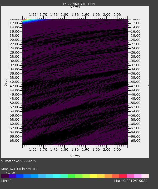
| Estimated Moho Depth: |
10.0 km |
| Estimated Crust Vp/Vs: |
1.60 |
| Assumed Crust Vp: |
6.232 km/s |
| Estimated Crust Vs: |
3.895 km/s |
| Estimated Crust Poisson's Ratio: |
0.18 |
|
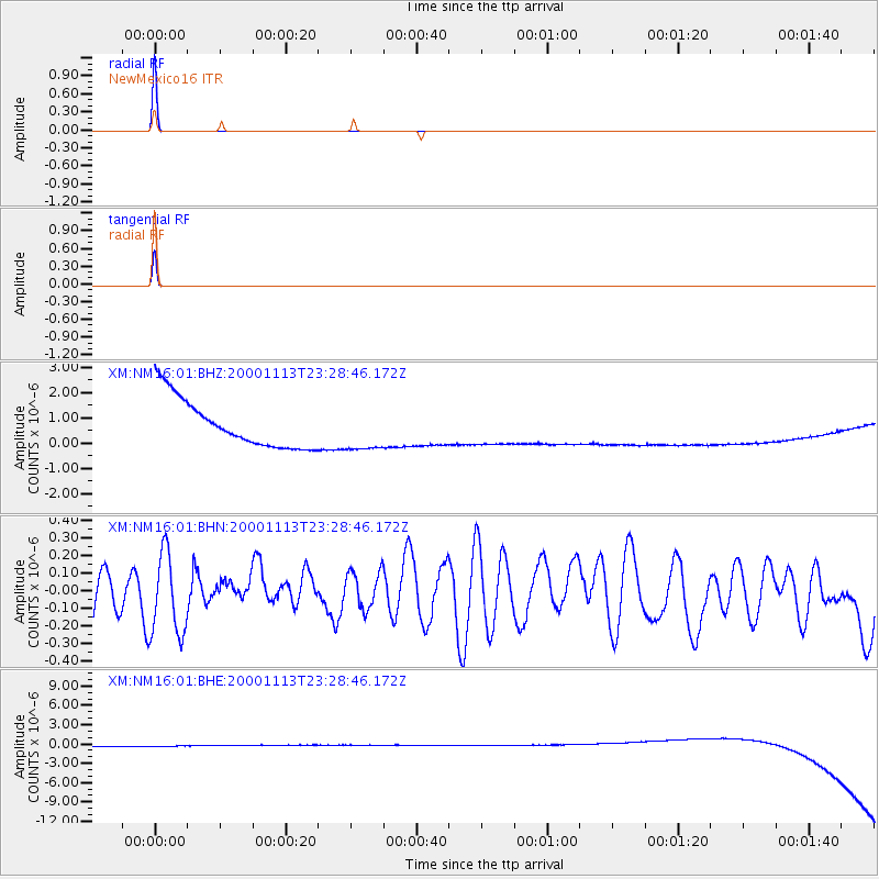
| Radial Match: |
99.999275 % |
| Radial Bump: |
2 |
| Transverse Match: |
99.98657 % |
| Transverse Bump: |
2 |
| SOD ConfigId: |
16820 |
| Insert Time: |
2010-02-26 17:26:02.042 +0000 |
| GWidth: |
2.5 |
| Max Bumps: |
400 |
| Tol: |
0.001 |
|
Signal To Noise
| Channel | StoN | STA | LTA |
| XM:NM16:01:BHN:20001113T23:28:46.172Z | 1.8184667 | 2.3741217E-7 | 1.3055624E-7 |
| XM:NM16:01:BHE:20001113T23:28:46.172Z | 0.907259 | 8.7291113E-7 | 9.62141E-7 |
| XM:NM16:01:BHZ:20001113T23:28:46.172Z | 0.90610725 | 8.7421387E-7 | 9.648018E-7 |
| Arrivals |
| Ps | 1.0 SECOND |
| PpPs | 4.1 SECOND |
| PsPs/PpSs | 5.1 SECOND |


