You are here: Home > Network List > O2 - Oklahoma Consolidated Temporary Seismic Networks Stations List
> Station FW04 Hopeton, Oklahoma, USA > Earthquake Result Viewer
FW04 Hopeton, Oklahoma, USA - Earthquake Result Viewer
| Earthquake location: |
Southern Peru |
| Earthquake latitude/longitude: |
-15.0/-70.4 |
| Earthquake time(UTC): |
2022/05/26 (146) 12:02:19 GMT |
| Earthquake Depth: |
212 km |
| Earthquake Magnitude: |
7.2 Mi |
| Earthquake Catalog/Contributor: |
NEIC PDE/at |
|
| Network: |
O2 Oklahoma Consolidated Temporary Seismic Networks |
| Station: |
FW04 Hopeton, Oklahoma, USA |
| Lat/Lon: |
36.60 N/98.67 W |
| Elevation: |
448 m |
|
| Distance: |
57.8 deg |
| Az: |
333.245 deg |
| Baz: |
147.278 deg |
| Ray Param: |
0.06253223 |
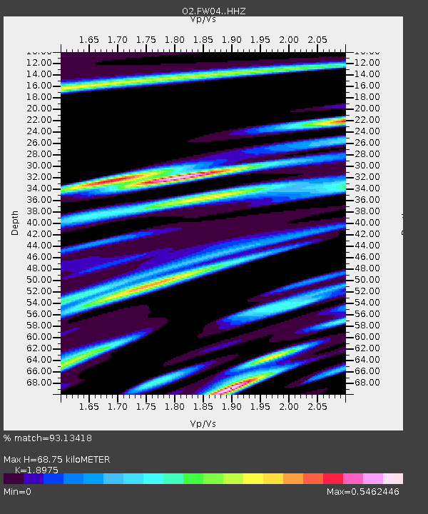
| Estimated Moho Depth: |
68.75 km |
| Estimated Crust Vp/Vs: |
1.90 |
| Assumed Crust Vp: |
6.426 km/s |
| Estimated Crust Vs: |
3.387 km/s |
| Estimated Crust Poisson's Ratio: |
0.31 |
|
| Radial Match: |
93.13418 % |
| Radial Bump: |
339 |
| Transverse Match: |
74.62422 % |
| Transverse Bump: |
400 |
| SOD ConfigId: |
27527651 |
| Insert Time: |
2022-06-09 12:27:43.144 +0000 |
| GWidth: |
2.5 |
| Max Bumps: |
400 |
| Tol: |
0.001 |
|

Signal To Noise
| Channel | StoN | STA | LTA |
| O2:FW04: :HHZ:20220526T12:11:17.544983Z | 78.60391 | 1.0035327E-5 | 1.2766957E-7 |
| O2:FW04: :HHN:20220526T12:11:17.544983Z | 19.125746 | 3.7277132E-6 | 1.949055E-7 |
| O2:FW04: :HHE:20220526T12:11:17.544983Z | 17.54117 | 3.2204312E-6 | 1.8359272E-7 |
| Arrivals |
| Ps | 10 SECOND |
| PpPs | 30 SECOND |
| PsPs/PpSs | 40 SECOND |


