You are here: Home > Network List > O2 - Oklahoma Consolidated Temporary Seismic Networks Stations List
> Station PW01 Pawnee, Oklahoma > Earthquake Result Viewer
PW01 Pawnee, Oklahoma - Earthquake Result Viewer
| Earthquake location: |
Southern Peru |
| Earthquake latitude/longitude: |
-15.0/-70.4 |
| Earthquake time(UTC): |
2022/05/26 (146) 12:02:19 GMT |
| Earthquake Depth: |
212 km |
| Earthquake Magnitude: |
7.2 Mi |
| Earthquake Catalog/Contributor: |
NEIC PDE/at |
|
| Network: |
O2 Oklahoma Consolidated Temporary Seismic Networks |
| Station: |
PW01 Pawnee, Oklahoma |
| Lat/Lon: |
36.40 N/96.93 W |
| Elevation: |
322 m |
|
| Distance: |
56.9 deg |
| Az: |
334.534 deg |
| Baz: |
149.001 deg |
| Ray Param: |
0.06311476 |
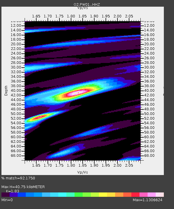
| Estimated Moho Depth: |
40.75 km |
| Estimated Crust Vp/Vs: |
1.83 |
| Assumed Crust Vp: |
6.483 km/s |
| Estimated Crust Vs: |
3.542 km/s |
| Estimated Crust Poisson's Ratio: |
0.29 |
|
| Radial Match: |
92.1758 % |
| Radial Bump: |
277 |
| Transverse Match: |
84.56671 % |
| Transverse Bump: |
400 |
| SOD ConfigId: |
27527651 |
| Insert Time: |
2022-06-09 12:28:01.353 +0000 |
| GWidth: |
2.5 |
| Max Bumps: |
400 |
| Tol: |
0.001 |
|

Signal To Noise
| Channel | StoN | STA | LTA |
| O2:PW01: :HHZ:20220526T12:11:11.255005Z | 165.36836 | 1.266165E-5 | 7.656634E-8 |
| O2:PW01: :HHN:20220526T12:11:11.255005Z | 27.884554 | 6.5919453E-6 | 2.364013E-7 |
| O2:PW01: :HHE:20220526T12:11:11.255005Z | 19.397224 | 2.1106218E-6 | 1.08810504E-7 |
| Arrivals |
| Ps | 5.5 SECOND |
| PpPs | 17 SECOND |
| PsPs/PpSs | 22 SECOND |


