You are here: Home > Network List > O2 - Oklahoma Consolidated Temporary Seismic Networks Stations List
> Station PW30 Pawnee, Oklahoma, USA > Earthquake Result Viewer
PW30 Pawnee, Oklahoma, USA - Earthquake Result Viewer
| Earthquake location: |
Southern Peru |
| Earthquake latitude/longitude: |
-15.0/-70.4 |
| Earthquake time(UTC): |
2022/05/26 (146) 12:02:19 GMT |
| Earthquake Depth: |
212 km |
| Earthquake Magnitude: |
7.2 Mi |
| Earthquake Catalog/Contributor: |
NEIC PDE/at |
|
| Network: |
O2 Oklahoma Consolidated Temporary Seismic Networks |
| Station: |
PW30 Pawnee, Oklahoma, USA |
| Lat/Lon: |
36.42 N/96.82 W |
| Elevation: |
314 m |
|
| Distance: |
56.9 deg |
| Az: |
334.632 deg |
| Baz: |
149.118 deg |
| Ray Param: |
0.063135475 |
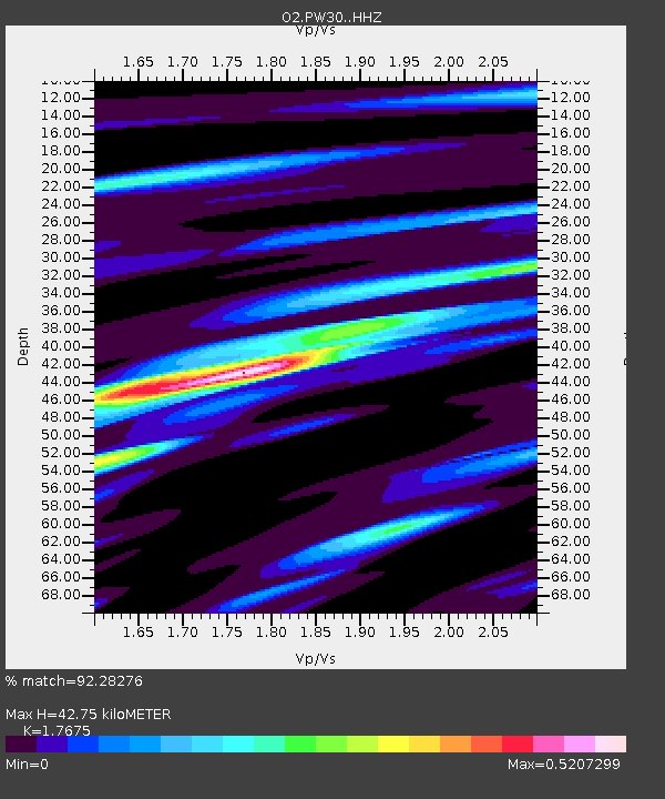
| Estimated Moho Depth: |
42.75 km |
| Estimated Crust Vp/Vs: |
1.77 |
| Assumed Crust Vp: |
6.483 km/s |
| Estimated Crust Vs: |
3.668 km/s |
| Estimated Crust Poisson's Ratio: |
0.26 |
|
| Radial Match: |
92.28276 % |
| Radial Bump: |
355 |
| Transverse Match: |
92.3023 % |
| Transverse Bump: |
371 |
| SOD ConfigId: |
27527651 |
| Insert Time: |
2022-06-09 12:28:13.750 +0000 |
| GWidth: |
2.5 |
| Max Bumps: |
400 |
| Tol: |
0.001 |
|

Signal To Noise
| Channel | StoN | STA | LTA |
| O2:PW30: :HHZ:20220526T12:11:11.030029Z | 110.11809 | 1.119395E-5 | 1.0165406E-7 |
| $trig.getChannelId() | $trig.getValue() | $trig.getSTA() | $trig.getLTA() |
| O2:PW30: :HHE:20220526T12:11:11.030029Z | 17.691748 | 3.2373518E-6 | 1.8298654E-7 |
| Arrivals |
| Ps | 5.3 SECOND |
| PpPs | 17 SECOND |
| PsPs/PpSs | 23 SECOND |


