You are here: Home > Network List > O2 - Oklahoma Consolidated Temporary Seismic Networks Stations List
> Station SC02 Maysville, Garvin & McClain Counties, OK, USA > Earthquake Result Viewer
SC02 Maysville, Garvin & McClain Counties, OK, USA - Earthquake Result Viewer
| Earthquake location: |
Southern Peru |
| Earthquake latitude/longitude: |
-15.0/-70.4 |
| Earthquake time(UTC): |
2022/05/26 (146) 12:02:19 GMT |
| Earthquake Depth: |
212 km |
| Earthquake Magnitude: |
7.2 Mi |
| Earthquake Catalog/Contributor: |
NEIC PDE/at |
|
| Network: |
O2 Oklahoma Consolidated Temporary Seismic Networks |
| Station: |
SC02 Maysville, Garvin & McClain Counties, OK, USA |
| Lat/Lon: |
34.80 N/97.39 W |
| Elevation: |
310 m |
|
| Distance: |
55.8 deg |
| Az: |
333.145 deg |
| Baz: |
147.965 deg |
| Ray Param: |
0.06385394 |
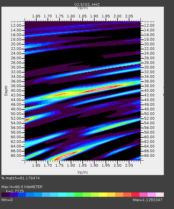
| Estimated Moho Depth: |
68.0 km |
| Estimated Crust Vp/Vs: |
1.77 |
| Assumed Crust Vp: |
6.426 km/s |
| Estimated Crust Vs: |
3.625 km/s |
| Estimated Crust Poisson's Ratio: |
0.27 |
|
| Radial Match: |
91.178474 % |
| Radial Bump: |
366 |
| Transverse Match: |
77.83277 % |
| Transverse Bump: |
363 |
| SOD ConfigId: |
27527651 |
| Insert Time: |
2022-06-09 12:28:20.146 +0000 |
| GWidth: |
2.5 |
| Max Bumps: |
400 |
| Tol: |
0.001 |
|

Signal To Noise
| Channel | StoN | STA | LTA |
| O2:SC02: :HHZ:20220526T12:11:03.030029Z | 175.5199 | 1.4819474E-5 | 8.443187E-8 |
| O2:SC02: :HHN:20220526T12:11:03.030029Z | 22.65925 | 3.414723E-6 | 1.5069885E-7 |
| O2:SC02: :HHE:20220526T12:11:03.030029Z | 15.403079 | 2.1529586E-6 | 1.3977456E-7 |
| Arrivals |
| Ps | 8.6 SECOND |
| PpPs | 28 SECOND |
| PsPs/PpSs | 36 SECOND |


