You are here: Home > Network List > OK - Oklahoma Seismic Network Stations List
> Station WILB Wilburton, Oklahoma, USA > Earthquake Result Viewer
WILB Wilburton, Oklahoma, USA - Earthquake Result Viewer
| Earthquake location: |
Southern Peru |
| Earthquake latitude/longitude: |
-15.0/-70.4 |
| Earthquake time(UTC): |
2022/05/26 (146) 12:02:19 GMT |
| Earthquake Depth: |
212 km |
| Earthquake Magnitude: |
7.2 Mi |
| Earthquake Catalog/Contributor: |
NEIC PDE/at |
|
| Network: |
OK Oklahoma Seismic Network |
| Station: |
WILB Wilburton, Oklahoma, USA |
| Lat/Lon: |
34.94 N/95.39 W |
| Elevation: |
710 m |
|
| Distance: |
55.0 deg |
| Az: |
334.951 deg |
| Baz: |
150.13 deg |
| Ray Param: |
0.06433061 |
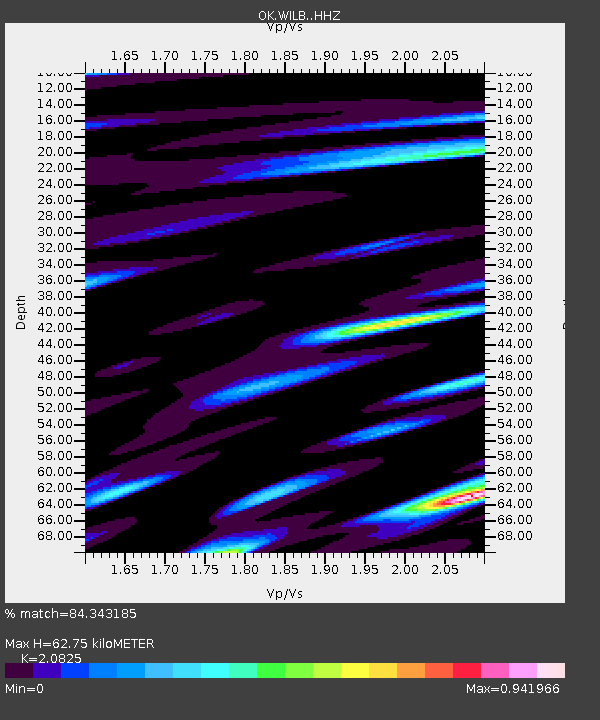
| Estimated Moho Depth: |
62.75 km |
| Estimated Crust Vp/Vs: |
2.08 |
| Assumed Crust Vp: |
6.498 km/s |
| Estimated Crust Vs: |
3.12 km/s |
| Estimated Crust Poisson's Ratio: |
0.35 |
|
| Radial Match: |
84.343185 % |
| Radial Bump: |
400 |
| Transverse Match: |
88.996185 % |
| Transverse Bump: |
400 |
| SOD ConfigId: |
27527651 |
| Insert Time: |
2022-06-09 12:29:46.568 +0000 |
| GWidth: |
2.5 |
| Max Bumps: |
400 |
| Tol: |
0.001 |
|

Signal To Noise
| Channel | StoN | STA | LTA |
| OK:WILB: :HHZ:20220526T12:10:57.940002Z | 65.24436 | 3.493768E-6 | 5.3548963E-8 |
| OK:WILB: :HHN:20220526T12:10:57.940002Z | 7.504221 | 3.4275809E-7 | 4.5675375E-8 |
| OK:WILB: :HHE:20220526T12:10:57.940002Z | 27.187115 | 1.2863084E-6 | 4.731316E-8 |
| Arrivals |
| Ps | 11 SECOND |
| PpPs | 28 SECOND |
| PsPs/PpSs | 39 SECOND |


