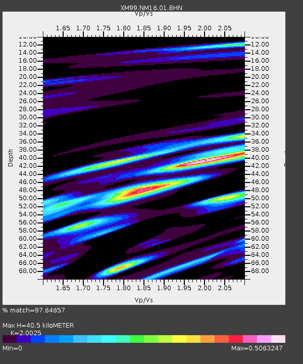
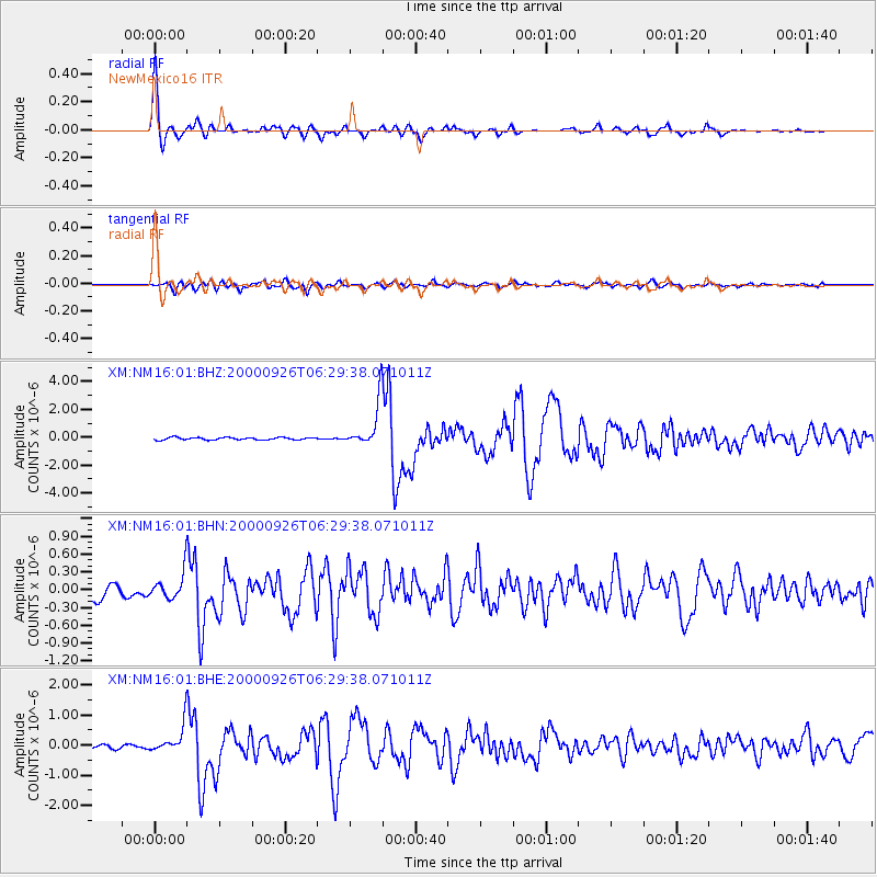
NM16 NewMexico16 - Earthquake Result Viewer

Earthquake location: Tonga Islands
Earthquake latitude/longitude: -17.2/-173.9
Earthquake time(UTC): 2000/09/26 (270) 06:17:52 GMT
Earthquake Depth: 56 km
Earthquake Magnitude: 6.1 MB, 6.1 MS, 6.4 MW, 6.1 ME
Earthquake Catalog/Contributor: WHDF/NEIC
Network: XM Rio Grande Seismic Transect
Station: NM16 NewMexico16
Lat/Lon: 33.17 N/105.13 W
Elevation: 1625 m
Distance: 82.5 deg
Az: 52.058 deg
Baz: 244.013 deg
Ray Param: 0.046723884
Estimated Moho Depth: 40.5 km
Estimated Crust Vp/Vs: 2.00
Assumed Crust Vp: 6.232 km/s
Estimated Crust Vs: 3.112 km/s
Estimated Crust Poisson's Ratio: 0.33
Radial Match: 97.64657 %
Radial Bump: 331
Transverse Match: 85.73205 %
Transverse Bump: 400
SOD ConfigId: 16820
Insert Time: 2010-02-26 17:26:05.724 +0000
GWidth: 2.5
Max Bumps: 400
Tol: 0.001

Signal To Noise

ChannelStoNSTALTA
XM:NM16:01:BHN:20000926T06:29:38.071011Z2.33157632.2686729E-79.7302106E-8
XM:NM16:01:BHE:20000926T06:29:38.071011Z4.4344364.717033E-71.0637278E-7
XM:NM16:01:BHZ:20000926T06:29:38.071011Z18.3628791.5871722E-68.643373E-8
Arrivals
Ps6.7 SECOND
PpPs19 SECOND
PsPs/PpSs26 SECOND