You are here: Home > Network List > TX - Texas Seismological Network Stations List
> Station 435B Jarrell, TX, USA > Earthquake Result Viewer
435B Jarrell, TX, USA - Earthquake Result Viewer
| Earthquake location: |
Southern Peru |
| Earthquake latitude/longitude: |
-15.0/-70.4 |
| Earthquake time(UTC): |
2022/05/26 (146) 12:02:19 GMT |
| Earthquake Depth: |
212 km |
| Earthquake Magnitude: |
7.2 Mi |
| Earthquake Catalog/Contributor: |
NEIC PDE/at |
|
| Network: |
TX Texas Seismological Network |
| Station: |
435B Jarrell, TX, USA |
| Lat/Lon: |
30.78 N/97.58 W |
| Elevation: |
248 m |
|
| Distance: |
52.5 deg |
| Az: |
330.289 deg |
| Baz: |
146.184 deg |
| Ray Param: |
0.065963954 |
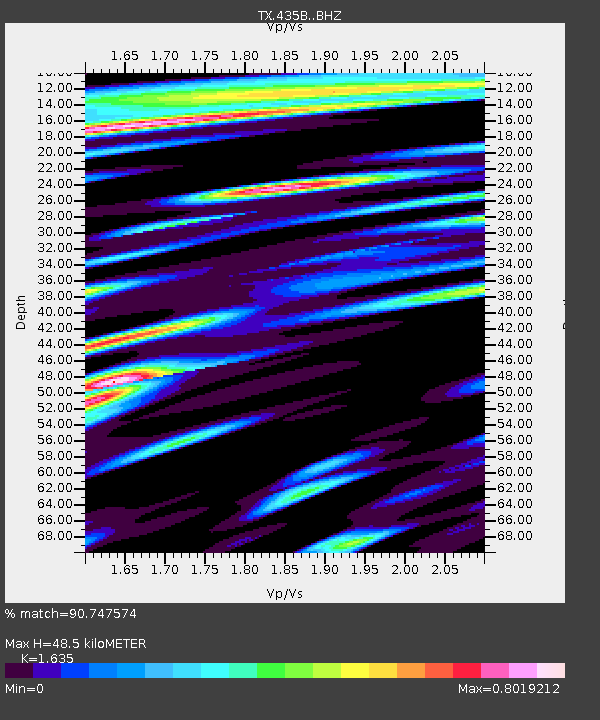
| Estimated Moho Depth: |
48.5 km |
| Estimated Crust Vp/Vs: |
1.63 |
| Assumed Crust Vp: |
6.347 km/s |
| Estimated Crust Vs: |
3.882 km/s |
| Estimated Crust Poisson's Ratio: |
0.20 |
|
| Radial Match: |
90.747574 % |
| Radial Bump: |
400 |
| Transverse Match: |
79.897446 % |
| Transverse Bump: |
400 |
| SOD ConfigId: |
27527651 |
| Insert Time: |
2022-06-09 12:33:09.219 +0000 |
| GWidth: |
2.5 |
| Max Bumps: |
400 |
| Tol: |
0.001 |
|

Signal To Noise
| Channel | StoN | STA | LTA |
| TX:435B: :BHZ:20220526T12:10:39.498993Z | 53.230545 | 7.0690103E-6 | 1.3279988E-7 |
| TX:435B: :BHN:20220526T12:10:39.498993Z | 29.53647 | 2.2545973E-6 | 7.633266E-8 |
| TX:435B: :BHE:20220526T12:10:39.498993Z | 16.456003 | 1.1095633E-6 | 6.742605E-8 |
| Arrivals |
| Ps | 5.1 SECOND |
| PpPs | 19 SECOND |
| PsPs/PpSs | 24 SECOND |


