You are here: Home > Network List > TX - Texas Seismological Network Stations List
> Station FW15 Z > Earthquake Result Viewer
FW15 Z - Earthquake Result Viewer
| Earthquake location: |
Southern Peru |
| Earthquake latitude/longitude: |
-15.0/-70.4 |
| Earthquake time(UTC): |
2022/05/26 (146) 12:02:19 GMT |
| Earthquake Depth: |
212 km |
| Earthquake Magnitude: |
7.2 Mi |
| Earthquake Catalog/Contributor: |
NEIC PDE/at |
|
| Network: |
TX Texas Seismological Network |
| Station: |
FW15 Z |
| Lat/Lon: |
32.70 N/97.37 W |
| Elevation: |
192 m |
|
| Distance: |
54.0 deg |
| Az: |
331.793 deg |
| Baz: |
147.198 deg |
| Ray Param: |
0.06499873 |
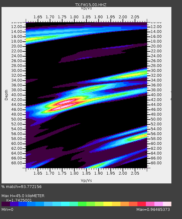
| Estimated Moho Depth: |
45.0 km |
| Estimated Crust Vp/Vs: |
1.74 |
| Assumed Crust Vp: |
6.38 km/s |
| Estimated Crust Vs: |
3.662 km/s |
| Estimated Crust Poisson's Ratio: |
0.25 |
|
| Radial Match: |
93.772156 % |
| Radial Bump: |
400 |
| Transverse Match: |
82.77193 % |
| Transverse Bump: |
400 |
| SOD ConfigId: |
27527651 |
| Insert Time: |
2022-06-09 12:33:42.614 +0000 |
| GWidth: |
2.5 |
| Max Bumps: |
400 |
| Tol: |
0.001 |
|
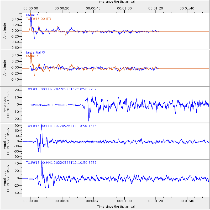
Signal To Noise
| Channel | StoN | STA | LTA |
| TX:FW15:00:HHZ:20220526T12:10:50.375Z | 45.032505 | 1.22203965E-5 | 2.7136835E-7 |
| TX:FW15:00:HH1:20220526T12:10:50.375Z | 6.937149 | 3.1384297E-6 | 4.5240915E-7 |
| TX:FW15:00:HH2:20220526T12:10:50.375Z | 6.364011 | 1.6327643E-6 | 2.5656215E-7 |
| Arrivals |
| Ps | 5.5 SECOND |
| PpPs | 18 SECOND |
| PsPs/PpSs | 24 SECOND |


