You are here: Home > Network List > TX - Texas Seismological Network Stations List
> Station MB02 Rankin > Earthquake Result Viewer
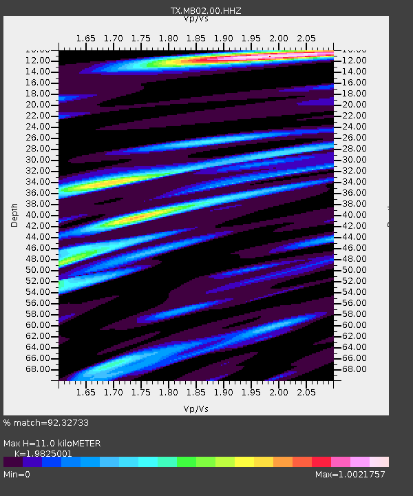
MB02 Rankin - Earthquake Result Viewer
| Earthquake location: |
Southern Peru |
| Earthquake latitude/longitude: |
-15.0/-70.4 |
| Earthquake time(UTC): |
2022/05/26 (146) 12:02:19 GMT |
| Earthquake Depth: |
212 km |
| Earthquake Magnitude: |
7.2 Mi |
| Earthquake Catalog/Contributor: |
NEIC PDE/at |
|
| Network: |
TX Texas Seismological Network |
| Station: |
MB02 Rankin |
| Lat/Lon: |
31.20 N/102.04 W |
| Elevation: |
768 m |
|
| Distance: |
55.1 deg |
| Az: |
326.756 deg |
| Baz: |
141.814 deg |
| Ray Param: |
0.06430787 |
| Estimated Moho Depth: |
11.0 km |
| Estimated Crust Vp/Vs: |
1.98 |
| Assumed Crust Vp: |
6.121 km/s |
| Estimated Crust Vs: |
3.087 km/s |
| Estimated Crust Poisson's Ratio: |
0.33 |
|
| Radial Match: |
92.32733 % |
| Radial Bump: |
377 |
| Transverse Match: |
88.36936 % |
| Transverse Bump: |
400 |
| SOD ConfigId: |
27527651 |
| Insert Time: |
2022-06-09 12:33:46.494 +0000 |
| GWidth: |
2.5 |
| Max Bumps: |
400 |
| Tol: |
0.001 |
|

Signal To Noise
| Channel | StoN | STA | LTA |
| TX:MB02:00:HHZ:20220526T12:10:58.140015Z | 165.609 | 6.7062665E-6 | 4.049458E-8 |
| TX:MB02:00:HH1:20220526T12:10:58.140015Z | 53.899956 | 1.5750745E-6 | 2.9222184E-8 |
| TX:MB02:00:HH2:20220526T12:10:58.140015Z | 40.73014 | 2.2853658E-6 | 5.6109943E-8 |
| Arrivals |
| Ps | 1.8 SECOND |
| PpPs | 5.1 SECOND |
| PsPs/PpSs | 7.0 SECOND |


