You are here: Home > Network List > TX - Texas Seismological Network Stations List
> Station PB29 Culberson North > Earthquake Result Viewer
PB29 Culberson North - Earthquake Result Viewer
| Earthquake location: |
Southern Peru |
| Earthquake latitude/longitude: |
-15.0/-70.4 |
| Earthquake time(UTC): |
2022/05/26 (146) 12:02:19 GMT |
| Earthquake Depth: |
212 km |
| Earthquake Magnitude: |
7.2 Mi |
| Earthquake Catalog/Contributor: |
NEIC PDE/at |
|
| Network: |
TX Texas Seismological Network |
| Station: |
PB29 Culberson North |
| Lat/Lon: |
31.75 N/104.51 W |
| Elevation: |
1242 m |
|
| Distance: |
56.8 deg |
| Az: |
325.202 deg |
| Baz: |
139.657 deg |
| Ray Param: |
0.06317278 |
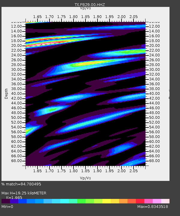
| Estimated Moho Depth: |
19.25 km |
| Estimated Crust Vp/Vs: |
1.66 |
| Assumed Crust Vp: |
6.361 km/s |
| Estimated Crust Vs: |
3.82 km/s |
| Estimated Crust Poisson's Ratio: |
0.22 |
|
| Radial Match: |
94.780495 % |
| Radial Bump: |
400 |
| Transverse Match: |
76.208176 % |
| Transverse Bump: |
400 |
| SOD ConfigId: |
27527651 |
| Insert Time: |
2022-06-09 12:34:21.608 +0000 |
| GWidth: |
2.5 |
| Max Bumps: |
400 |
| Tol: |
0.001 |
|

Signal To Noise
| Channel | StoN | STA | LTA |
| TX:PB29:00:HHZ:20220526T12:11:10.630005Z | 27.040031 | 6.1528626E-6 | 2.2754642E-7 |
| TX:PB29:00:HH1:20220526T12:11:10.630005Z | 8.698488 | 1.6914198E-6 | 1.9444985E-7 |
| TX:PB29:00:HH2:20220526T12:11:10.630005Z | 8.890412 | 1.6892548E-6 | 1.900086E-7 |
| Arrivals |
| Ps | 2.1 SECOND |
| PpPs | 7.7 SECOND |
| PsPs/PpSs | 9.8 SECOND |


