You are here: Home > Network List > UW - Pacific Northwest Regional Seismic Network Stations List
> Station DOSE Dosewallips old TA.C04A, WA > Earthquake Result Viewer
DOSE Dosewallips old TA.C04A, WA - Earthquake Result Viewer
| Earthquake location: |
Southern Peru |
| Earthquake latitude/longitude: |
-15.0/-70.4 |
| Earthquake time(UTC): |
2022/05/26 (146) 12:02:19 GMT |
| Earthquake Depth: |
212 km |
| Earthquake Magnitude: |
7.2 Mi |
| Earthquake Catalog/Contributor: |
NEIC PDE/at |
|
| Network: |
UW Pacific Northwest Regional Seismic Network |
| Station: |
DOSE Dosewallips old TA.C04A, WA |
| Lat/Lon: |
47.72 N/122.97 W |
| Elevation: |
53 m |
|
| Distance: |
78.1 deg |
| Az: |
326.764 deg |
| Baz: |
128.338 deg |
| Ray Param: |
0.04935857 |
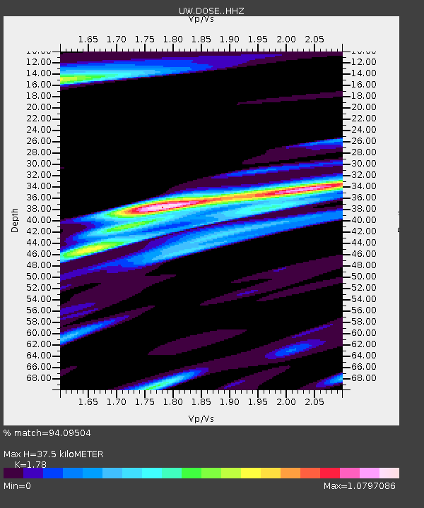
| Estimated Moho Depth: |
37.5 km |
| Estimated Crust Vp/Vs: |
1.78 |
| Assumed Crust Vp: |
6.566 km/s |
| Estimated Crust Vs: |
3.689 km/s |
| Estimated Crust Poisson's Ratio: |
0.27 |
|
| Radial Match: |
94.09504 % |
| Radial Bump: |
400 |
| Transverse Match: |
79.51399 % |
| Transverse Bump: |
400 |
| SOD ConfigId: |
27527651 |
| Insert Time: |
2022-06-09 12:38:25.533 +0000 |
| GWidth: |
2.5 |
| Max Bumps: |
400 |
| Tol: |
0.001 |
|

Signal To Noise
| Channel | StoN | STA | LTA |
| UW:DOSE: :HHZ:20220526T12:13:23.01001Z | 16.18537 | 1.7036144E-6 | 1.0525644E-7 |
| UW:DOSE: :HHN:20220526T12:13:23.01001Z | 5.0974417 | 6.0586706E-7 | 1.1885709E-7 |
| UW:DOSE: :HHE:20220526T12:13:23.01001Z | 8.452085 | 8.504268E-7 | 1.006174E-7 |
| Arrivals |
| Ps | 4.6 SECOND |
| PpPs | 15 SECOND |
| PsPs/PpSs | 20 SECOND |


