You are here: Home > Network List > UW - Pacific Northwest Regional Seismic Network Stations List
> Station HILL La Conner, WA, USA > Earthquake Result Viewer
HILL La Conner, WA, USA - Earthquake Result Viewer
| Earthquake location: |
Southern Peru |
| Earthquake latitude/longitude: |
-15.0/-70.4 |
| Earthquake time(UTC): |
2022/05/26 (146) 12:02:19 GMT |
| Earthquake Depth: |
212 km |
| Earthquake Magnitude: |
7.2 Mi |
| Earthquake Catalog/Contributor: |
NEIC PDE/at |
|
| Network: |
UW Pacific Northwest Regional Seismic Network |
| Station: |
HILL La Conner, WA, USA |
| Lat/Lon: |
48.39 N/122.45 W |
| Elevation: |
38 m |
|
| Distance: |
78.2 deg |
| Az: |
327.524 deg |
| Baz: |
128.883 deg |
| Ray Param: |
0.04926024 |
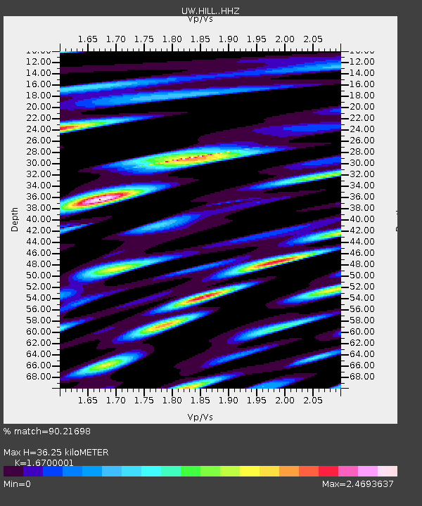
| Estimated Moho Depth: |
36.25 km |
| Estimated Crust Vp/Vs: |
1.67 |
| Assumed Crust Vp: |
6.566 km/s |
| Estimated Crust Vs: |
3.932 km/s |
| Estimated Crust Poisson's Ratio: |
0.22 |
|
| Radial Match: |
90.21698 % |
| Radial Bump: |
400 |
| Transverse Match: |
71.26085 % |
| Transverse Bump: |
400 |
| SOD ConfigId: |
27527651 |
| Insert Time: |
2022-06-09 12:38:41.787 +0000 |
| GWidth: |
2.5 |
| Max Bumps: |
400 |
| Tol: |
0.001 |
|

Signal To Noise
| Channel | StoN | STA | LTA |
| UW:HILL: :HHZ:20220526T12:13:23.789978Z | 24.773693 | 4.5017364E-6 | 1.8171438E-7 |
| UW:HILL: :HHN:20220526T12:13:23.789978Z | 3.7267628 | 7.9552234E-7 | 2.1346203E-7 |
| UW:HILL: :HHE:20220526T12:13:23.789978Z | 14.256225 | 2.6230525E-6 | 1.8399349E-7 |
| Arrivals |
| Ps | 3.8 SECOND |
| PpPs | 14 SECOND |
| PsPs/PpSs | 18 SECOND |


