You are here: Home > Network List > UW - Pacific Northwest Regional Seismic Network Stations List
> Station NEMA NEMA Site, Pacific County, WA, USA > Earthquake Result Viewer
NEMA NEMA Site, Pacific County, WA, USA - Earthquake Result Viewer
| Earthquake location: |
Southern Peru |
| Earthquake latitude/longitude: |
-15.0/-70.4 |
| Earthquake time(UTC): |
2022/05/26 (146) 12:02:19 GMT |
| Earthquake Depth: |
212 km |
| Earthquake Magnitude: |
7.2 Mi |
| Earthquake Catalog/Contributor: |
NEIC PDE/at |
|
| Network: |
UW Pacific Northwest Regional Seismic Network |
| Station: |
NEMA NEMA Site, Pacific County, WA, USA |
| Lat/Lon: |
46.50 N/123.75 W |
| Elevation: |
509 m |
|
| Distance: |
77.7 deg |
| Az: |
325.445 deg |
| Baz: |
127.493 deg |
| Ray Param: |
0.049578287 |
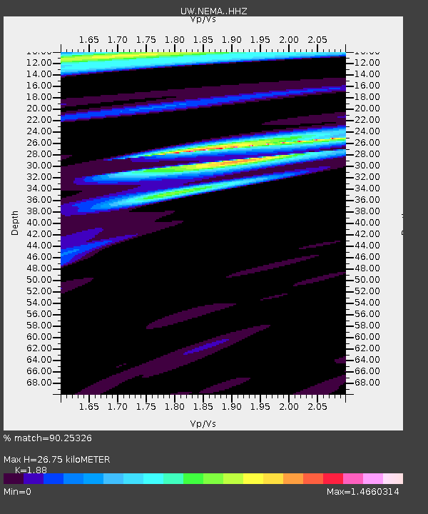
| Estimated Moho Depth: |
26.75 km |
| Estimated Crust Vp/Vs: |
1.88 |
| Assumed Crust Vp: |
6.566 km/s |
| Estimated Crust Vs: |
3.493 km/s |
| Estimated Crust Poisson's Ratio: |
0.30 |
|
| Radial Match: |
90.25326 % |
| Radial Bump: |
400 |
| Transverse Match: |
84.92712 % |
| Transverse Bump: |
400 |
| SOD ConfigId: |
27527651 |
| Insert Time: |
2022-06-09 12:39:15.334 +0000 |
| GWidth: |
2.5 |
| Max Bumps: |
400 |
| Tol: |
0.001 |
|

Signal To Noise
| Channel | StoN | STA | LTA |
| UW:NEMA: :HHZ:20220526T12:13:21.200012Z | 14.049656 | 1.8458602E-6 | 1.3138117E-7 |
| UW:NEMA: :HHN:20220526T12:13:21.200012Z | 4.242169 | 5.928863E-7 | 1.3976017E-7 |
| UW:NEMA: :HHE:20220526T12:13:21.200012Z | 2.3339198 | 4.9742584E-7 | 2.1312893E-7 |
| Arrivals |
| Ps | 3.7 SECOND |
| PpPs | 11 SECOND |
| PsPs/PpSs | 15 SECOND |


