You are here: Home > Network List > UW - Pacific Northwest Regional Seismic Network Stations List
> Station PRIN Pacific Rim Institute, Coupeville, WA, USA > Earthquake Result Viewer
PRIN Pacific Rim Institute, Coupeville, WA, USA - Earthquake Result Viewer
| Earthquake location: |
Southern Peru |
| Earthquake latitude/longitude: |
-15.0/-70.4 |
| Earthquake time(UTC): |
2022/05/26 (146) 12:02:19 GMT |
| Earthquake Depth: |
212 km |
| Earthquake Magnitude: |
7.2 Mi |
| Earthquake Catalog/Contributor: |
NEIC PDE/at |
|
| Network: |
UW Pacific Northwest Regional Seismic Network |
| Station: |
PRIN Pacific Rim Institute, Coupeville, WA, USA |
| Lat/Lon: |
48.21 N/122.63 W |
| Elevation: |
63 m |
|
| Distance: |
78.2 deg |
| Az: |
327.305 deg |
| Baz: |
128.701 deg |
| Ray Param: |
0.04927047 |
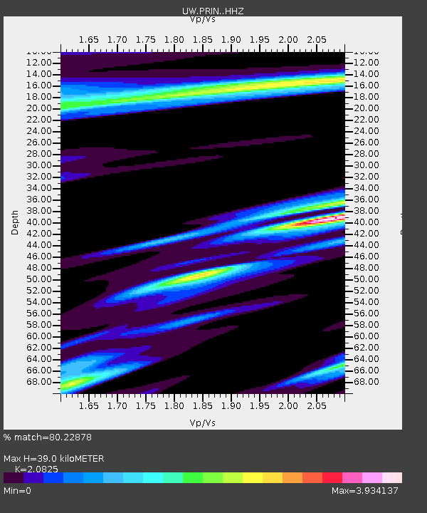
| Estimated Moho Depth: |
39.0 km |
| Estimated Crust Vp/Vs: |
2.08 |
| Assumed Crust Vp: |
6.566 km/s |
| Estimated Crust Vs: |
3.153 km/s |
| Estimated Crust Poisson's Ratio: |
0.35 |
|
| Radial Match: |
80.22878 % |
| Radial Bump: |
395 |
| Transverse Match: |
74.85938 % |
| Transverse Bump: |
393 |
| SOD ConfigId: |
27527651 |
| Insert Time: |
2022-06-09 12:39:31.774 +0000 |
| GWidth: |
2.5 |
| Max Bumps: |
400 |
| Tol: |
0.001 |
|

Signal To Noise
| Channel | StoN | STA | LTA |
| UW:PRIN: :HHZ:20220526T12:13:23.710022Z | 6.409912 | 3.187904E-6 | 4.973397E-7 |
| UW:PRIN: :HHN:20220526T12:13:23.710022Z | 0.7838368 | 1.0386786E-6 | 1.3251212E-6 |
| UW:PRIN: :HHE:20220526T12:13:23.710022Z | 1.4810532 | 1.053197E-6 | 7.111135E-7 |
| Arrivals |
| Ps | 6.6 SECOND |
| PpPs | 18 SECOND |
| PsPs/PpSs | 24 SECOND |


