You are here: Home > Network List > YU19 - Cornell University Earth Source Heat seismic network (Cornell_ESH (2019-2024)) Stations List
> Station B01A Lansing > Earthquake Result Viewer
B01A Lansing - Earthquake Result Viewer
| Earthquake location: |
Southern Peru |
| Earthquake latitude/longitude: |
-15.0/-70.4 |
| Earthquake time(UTC): |
2022/05/26 (146) 12:02:19 GMT |
| Earthquake Depth: |
212 km |
| Earthquake Magnitude: |
7.2 Mi |
| Earthquake Catalog/Contributor: |
NEIC PDE/at |
|
| Network: |
YU Cornell University Earth Source Heat seismic network (Cornell_ESH (2019-2024)) |
| Station: |
B01A Lansing |
| Lat/Lon: |
42.55 N/76.51 W |
| Elevation: |
271 m |
|
| Distance: |
57.5 deg |
| Az: |
354.656 deg |
| Baz: |
173.003 deg |
| Ray Param: |
0.06270885 |
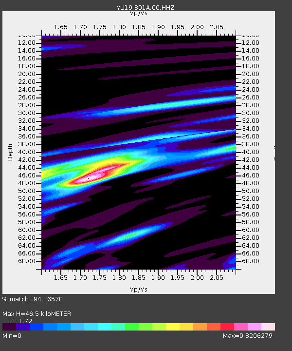
| Estimated Moho Depth: |
46.5 km |
| Estimated Crust Vp/Vs: |
1.72 |
| Assumed Crust Vp: |
6.476 km/s |
| Estimated Crust Vs: |
3.765 km/s |
| Estimated Crust Poisson's Ratio: |
0.24 |
|
| Radial Match: |
94.16578 % |
| Radial Bump: |
400 |
| Transverse Match: |
88.59205 % |
| Transverse Bump: |
400 |
| SOD ConfigId: |
27527651 |
| Insert Time: |
2022-06-09 12:42:32.673 +0000 |
| GWidth: |
2.5 |
| Max Bumps: |
400 |
| Tol: |
0.001 |
|

Signal To Noise
| Channel | StoN | STA | LTA |
| YU:B01A:00:HHZ:20220526T12:11:15.47998Z | 66.502594 | 6.991048E-6 | 1.05124435E-7 |
| YU:B01A:00:HHN:20220526T12:11:15.47998Z | 28.96272 | 2.9071284E-6 | 1.0037484E-7 |
| YU:B01A:00:HHE:20220526T12:11:15.47998Z | 15.589091 | 1.0849815E-6 | 6.959876E-8 |
| Arrivals |
| Ps | 5.4 SECOND |
| PpPs | 19 SECOND |
| PsPs/PpSs | 24 SECOND |


