You are here: Home > Network List > 4T - Texas Seismological Network (TexNet Stations) Stations List
> Station NM01 Eunice > Earthquake Result Viewer
NM01 Eunice - Earthquake Result Viewer
| Earthquake location: |
Southern Peru |
| Earthquake latitude/longitude: |
-15.0/-70.4 |
| Earthquake time(UTC): |
2022/05/26 (146) 12:02:19 GMT |
| Earthquake Depth: |
212 km |
| Earthquake Magnitude: |
7.2 Mi |
| Earthquake Catalog/Contributor: |
NEIC PDE/at |
|
| Network: |
4T Texas Seismological Network (TexNet Stations) |
| Station: |
NM01 Eunice |
| Lat/Lon: |
32.36 N/103.40 W |
| Elevation: |
1051 m |
|
| Distance: |
56.7 deg |
| Az: |
326.532 deg |
| Baz: |
140.975 deg |
| Ray Param: |
0.06326145 |
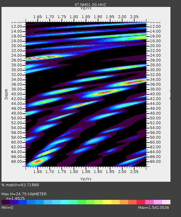
| Estimated Moho Depth: |
24.75 km |
| Estimated Crust Vp/Vs: |
1.65 |
| Assumed Crust Vp: |
6.129 km/s |
| Estimated Crust Vs: |
3.709 km/s |
| Estimated Crust Poisson's Ratio: |
0.21 |
|
| Radial Match: |
93.71998 % |
| Radial Bump: |
400 |
| Transverse Match: |
84.75278 % |
| Transverse Bump: |
400 |
| SOD ConfigId: |
27527651 |
| Insert Time: |
2022-06-09 12:42:33.303 +0000 |
| GWidth: |
2.5 |
| Max Bumps: |
400 |
| Tol: |
0.001 |
|

Signal To Noise
| Channel | StoN | STA | LTA |
| 4T:NM01:00:HHZ:20220526T12:11:09.619995Z | 103.52027 | 1.0824157E-5 | 1.0456074E-7 |
| 4T:NM01:00:HH1:20220526T12:11:09.619995Z | 25.1191 | 2.535297E-6 | 1.0093104E-7 |
| 4T:NM01:00:HH2:20220526T12:11:09.619995Z | 36.557323 | 2.9451114E-6 | 8.056146E-8 |
| Arrivals |
| Ps | 2.8 SECOND |
| PpPs | 10 SECOND |
| PsPs/PpSs | 13 SECOND |


