You are here: Home > Network List > AK - Alaska Regional Network Stations List
> Station HARP HAARP, Gakona, AK, USA > Earthquake Result Viewer
HARP HAARP, Gakona, AK, USA - Earthquake Result Viewer
| Earthquake location: |
Southeast Of Loyalty Islands |
| Earthquake latitude/longitude: |
-22.9/172.0 |
| Earthquake time(UTC): |
2022/05/26 (146) 15:38:03 GMT |
| Earthquake Depth: |
10 km |
| Earthquake Magnitude: |
6.9 Mi |
| Earthquake Catalog/Contributor: |
NEIC PDE/at |
|
| Network: |
AK Alaska Regional Network |
| Station: |
HARP HAARP, Gakona, AK, USA |
| Lat/Lon: |
62.40 N/145.16 W |
| Elevation: |
581 m |
|
| Distance: |
91.6 deg |
| Az: |
18.472 deg |
| Baz: |
218.849 deg |
| Ray Param: |
0.04158996 |
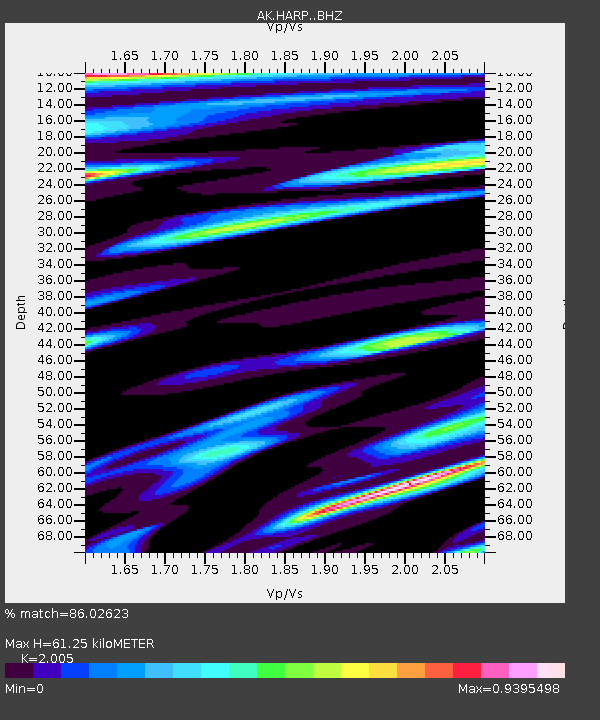
| Estimated Moho Depth: |
61.25 km |
| Estimated Crust Vp/Vs: |
2.01 |
| Assumed Crust Vp: |
6.566 km/s |
| Estimated Crust Vs: |
3.275 km/s |
| Estimated Crust Poisson's Ratio: |
0.33 |
|
| Radial Match: |
86.02623 % |
| Radial Bump: |
361 |
| Transverse Match: |
69.68217 % |
| Transverse Bump: |
400 |
| SOD ConfigId: |
27527651 |
| Insert Time: |
2022-06-09 15:41:56.511 +0000 |
| GWidth: |
2.5 |
| Max Bumps: |
400 |
| Tol: |
0.001 |
|

Signal To Noise
| Channel | StoN | STA | LTA |
| AK:HARP: :BHZ:20220526T15:50:38.299988Z | 11.06815 | 1.6789057E-6 | 1.5168803E-7 |
| AK:HARP: :BHN:20220526T15:50:38.299988Z | 5.002497 | 6.3897863E-7 | 1.2773192E-7 |
| AK:HARP: :BHE:20220526T15:50:38.299988Z | 4.0769496 | 5.1145395E-7 | 1.2545016E-7 |
| Arrivals |
| Ps | 9.6 SECOND |
| PpPs | 28 SECOND |
| PsPs/PpSs | 37 SECOND |


