You are here: Home > Network List > AK - Alaska Regional Network Stations List
> Station MESA Mesa, AK, USA > Earthquake Result Viewer
MESA Mesa, AK, USA - Earthquake Result Viewer
| Earthquake location: |
Southeast Of Loyalty Islands |
| Earthquake latitude/longitude: |
-22.9/172.0 |
| Earthquake time(UTC): |
2022/05/26 (146) 15:38:03 GMT |
| Earthquake Depth: |
10 km |
| Earthquake Magnitude: |
6.9 Mi |
| Earthquake Catalog/Contributor: |
NEIC PDE/at |
|
| Network: |
AK Alaska Regional Network |
| Station: |
MESA Mesa, AK, USA |
| Lat/Lon: |
60.18 N/141.95 W |
| Elevation: |
1907 m |
|
| Distance: |
90.9 deg |
| Az: |
21.093 deg |
| Baz: |
221.602 deg |
| Ray Param: |
0.04166905 |
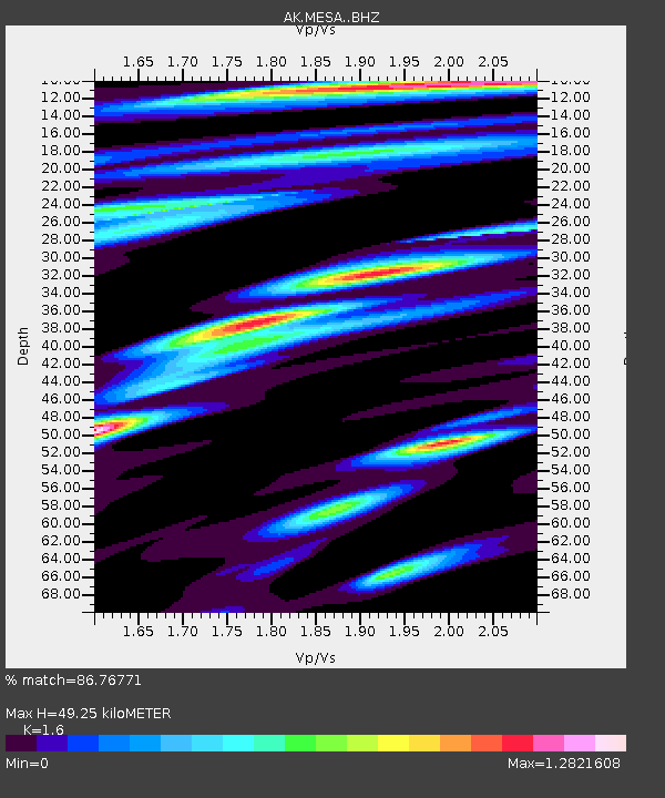
| Estimated Moho Depth: |
49.25 km |
| Estimated Crust Vp/Vs: |
1.60 |
| Assumed Crust Vp: |
6.566 km/s |
| Estimated Crust Vs: |
4.104 km/s |
| Estimated Crust Poisson's Ratio: |
0.18 |
|
| Radial Match: |
86.76771 % |
| Radial Bump: |
400 |
| Transverse Match: |
84.312325 % |
| Transverse Bump: |
400 |
| SOD ConfigId: |
27527651 |
| Insert Time: |
2022-06-09 15:42:53.209 +0000 |
| GWidth: |
2.5 |
| Max Bumps: |
400 |
| Tol: |
0.001 |
|

Signal To Noise
| Channel | StoN | STA | LTA |
| AK:MESA: :BHZ:20220526T15:50:35.067993Z | 19.725172 | 1.9665813E-6 | 9.969907E-8 |
| AK:MESA: :BHN:20220526T15:50:35.067993Z | 4.1885185 | 5.7224605E-7 | 1.3662255E-7 |
| AK:MESA: :BHE:20220526T15:50:35.067993Z | 4.356652 | 5.0213066E-7 | 1.152561E-7 |
| Arrivals |
| Ps | 4.6 SECOND |
| PpPs | 19 SECOND |
| PsPs/PpSs | 24 SECOND |


