You are here: Home > Network List > AK - Alaska Regional Network Stations List
> Station BAT Barry Arm Top, AK, USA > Earthquake Result Viewer
BAT Barry Arm Top, AK, USA - Earthquake Result Viewer
| Earthquake location: |
Southeast Of Loyalty Islands |
| Earthquake latitude/longitude: |
-22.9/172.0 |
| Earthquake time(UTC): |
2022/05/26 (146) 15:38:03 GMT |
| Earthquake Depth: |
10 km |
| Earthquake Magnitude: |
6.9 Mi |
| Earthquake Catalog/Contributor: |
NEIC PDE/at |
|
| Network: |
AK Alaska Regional Network |
| Station: |
BAT Barry Arm Top, AK, USA |
| Lat/Lon: |
61.14 N/148.18 W |
| Elevation: |
1027 m |
|
| Distance: |
89.7 deg |
| Az: |
18.102 deg |
| Baz: |
216.198 deg |
| Ray Param: |
0.041732773 |
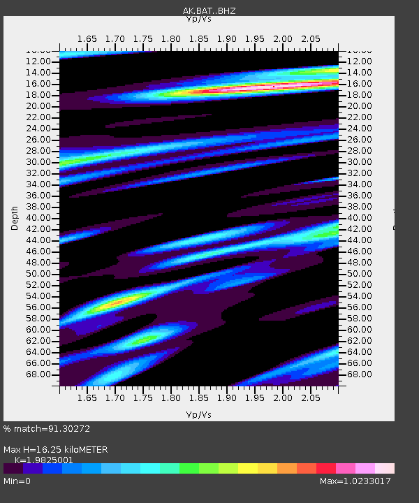
| Estimated Moho Depth: |
16.25 km |
| Estimated Crust Vp/Vs: |
1.98 |
| Assumed Crust Vp: |
6.566 km/s |
| Estimated Crust Vs: |
3.312 km/s |
| Estimated Crust Poisson's Ratio: |
0.33 |
|
| Radial Match: |
91.30272 % |
| Radial Bump: |
400 |
| Transverse Match: |
72.1952 % |
| Transverse Bump: |
400 |
| SOD ConfigId: |
27527651 |
| Insert Time: |
2022-06-09 15:44:18.676 +0000 |
| GWidth: |
2.5 |
| Max Bumps: |
400 |
| Tol: |
0.001 |
|

Signal To Noise
| Channel | StoN | STA | LTA |
| AK:BAT: :BHZ:20220526T15:50:29.640015Z | 25.27041 | 1.2534302E-6 | 4.9600708E-8 |
| AK:BAT: :BHN:20220526T15:50:29.640015Z | 12.21619 | 3.8804865E-7 | 3.176511E-8 |
| AK:BAT: :BHE:20220526T15:50:29.640015Z | 7.459528 | 2.7044192E-7 | 3.6254562E-8 |
| Arrivals |
| Ps | 2.5 SECOND |
| PpPs | 7.2 SECOND |
| PsPs/PpSs | 9.7 SECOND |


