You are here: Home > Network List > XM99 - Rio Grande Seismic Transect Stations List
> Station NM16 NewMexico16 > Earthquake Result Viewer
NM16 NewMexico16 - Earthquake Result Viewer
| Earthquake location: |
Southeast Of Loyalty Islands |
| Earthquake latitude/longitude: |
-22.0/170.1 |
| Earthquake time(UTC): |
2001/02/28 (059) 13:05:31 GMT |
| Earthquake Depth: |
10 km |
| Earthquake Magnitude: |
5.8 MB, 6.1 MS, 6.2 MW |
| Earthquake Catalog/Contributor: |
WHDF/NEIC |
|
| Network: |
XM Rio Grande Seismic Transect |
| Station: |
NM16 NewMexico16 |
| Lat/Lon: |
33.17 N/105.13 W |
| Elevation: |
1625 m |
|
| Distance: |
97.6 deg |
| Az: |
57.41 deg |
| Baz: |
248.798 deg |
| Ray Param: |
0.040172566 |
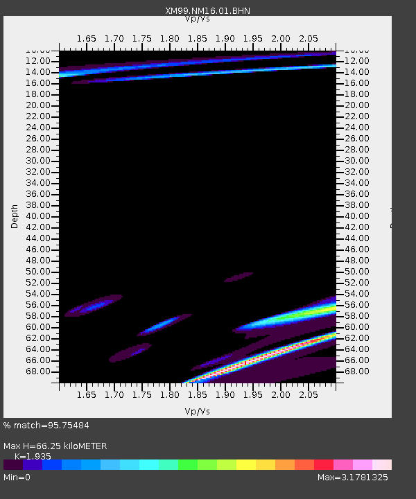
| Estimated Moho Depth: |
66.25 km |
| Estimated Crust Vp/Vs: |
1.93 |
| Assumed Crust Vp: |
6.232 km/s |
| Estimated Crust Vs: |
3.22 km/s |
| Estimated Crust Poisson's Ratio: |
0.32 |
|
| Radial Match: |
95.75484 % |
| Radial Bump: |
357 |
| Transverse Match: |
95.18911 % |
| Transverse Bump: |
379 |
| SOD ConfigId: |
3744 |
| Insert Time: |
2010-02-26 17:26:15.734 +0000 |
| GWidth: |
2.5 |
| Max Bumps: |
400 |
| Tol: |
0.001 |
|
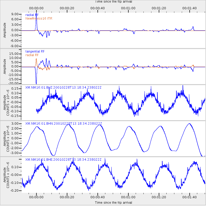
Signal To Noise
| Channel | StoN | STA | LTA |
| XM:NM16:01:BHN:20010228T13:18:34.238022Z | 1.5552297 | 2.3633932E-6 | 1.5196425E-6 |
| XM:NM16:01:BHE:20010228T13:18:34.238022Z | 1.4526935 | 1.2873662E-7 | 8.861926E-8 |
| XM:NM16:01:BHZ:20010228T13:18:34.238022Z | 1.4305109 | 9.08046E-8 | 6.347704E-8 |
| Arrivals |
| Ps | 10 SECOND |
| PpPs | 31 SECOND |
| PsPs/PpSs | 41 SECOND |


