You are here: Home > Network List > AV - Alaska Volcano Observatory Stations List
> Station KOKL Mount Kliuchef, Korovin Volcano, Alaska > Earthquake Result Viewer
KOKL Mount Kliuchef, Korovin Volcano, Alaska - Earthquake Result Viewer
| Earthquake location: |
Southeast Of Loyalty Islands |
| Earthquake latitude/longitude: |
-22.9/172.0 |
| Earthquake time(UTC): |
2022/05/26 (146) 15:38:03 GMT |
| Earthquake Depth: |
10 km |
| Earthquake Magnitude: |
6.9 Mi |
| Earthquake Catalog/Contributor: |
NEIC PDE/at |
|
| Network: |
AV Alaska Volcano Observatory |
| Station: |
KOKL Mount Kliuchef, Korovin Volcano, Alaska |
| Lat/Lon: |
52.32 N/174.20 W |
| Elevation: |
758 m |
|
| Distance: |
75.9 deg |
| Az: |
8.682 deg |
| Baz: |
193.108 deg |
| Ray Param: |
0.051386416 |
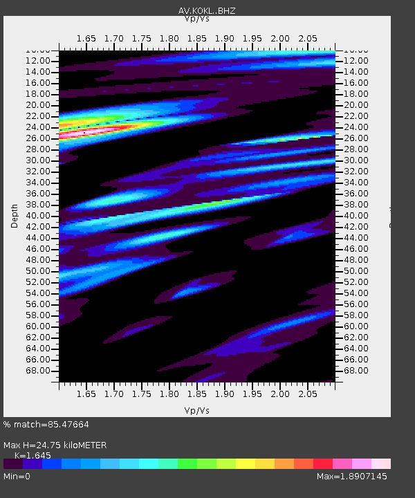
| Estimated Moho Depth: |
24.75 km |
| Estimated Crust Vp/Vs: |
1.64 |
| Assumed Crust Vp: |
5.88 km/s |
| Estimated Crust Vs: |
3.575 km/s |
| Estimated Crust Poisson's Ratio: |
0.21 |
|
| Radial Match: |
85.47664 % |
| Radial Bump: |
400 |
| Transverse Match: |
82.881836 % |
| Transverse Bump: |
400 |
| SOD ConfigId: |
27527651 |
| Insert Time: |
2022-06-09 15:47:00.368 +0000 |
| GWidth: |
2.5 |
| Max Bumps: |
400 |
| Tol: |
0.001 |
|

Signal To Noise
| Channel | StoN | STA | LTA |
| AV:KOKL: :BHZ:20220526T15:49:18.099976Z | 33.008514 | 3.6004499E-6 | 1.09076396E-7 |
| AV:KOKL: :BHN:20220526T15:49:18.099976Z | 15.003815 | 3.4368904E-6 | 2.2906778E-7 |
| AV:KOKL: :BHE:20220526T15:49:18.099976Z | 8.809403 | 1.5706079E-6 | 1.7828766E-7 |
| Arrivals |
| Ps | 2.8 SECOND |
| PpPs | 11 SECOND |
| PsPs/PpSs | 14 SECOND |


