You are here: Home > Network List > C - Chilean National Seismic Network Stations List
> Station GO06 Curarrehue (Paso Mamuil Malal), Chile > Earthquake Result Viewer
GO06 Curarrehue (Paso Mamuil Malal), Chile - Earthquake Result Viewer
| Earthquake location: |
Southeast Of Loyalty Islands |
| Earthquake latitude/longitude: |
-22.9/172.0 |
| Earthquake time(UTC): |
2022/05/26 (146) 15:38:03 GMT |
| Earthquake Depth: |
10 km |
| Earthquake Magnitude: |
6.9 Mi |
| Earthquake Catalog/Contributor: |
NEIC PDE/at |
|
| Network: |
C Chilean National Seismic Network |
| Station: |
GO06 Curarrehue (Paso Mamuil Malal), Chile |
| Lat/Lon: |
39.58 S/71.47 W |
| Elevation: |
1250 m |
|
| Distance: |
94.2 deg |
| Az: |
136.111 deg |
| Baz: |
235.815 deg |
| Ray Param: |
0.041107062 |
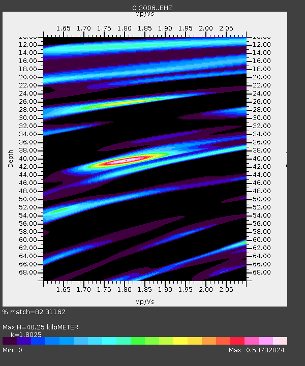
| Estimated Moho Depth: |
40.25 km |
| Estimated Crust Vp/Vs: |
1.80 |
| Assumed Crust Vp: |
6.597 km/s |
| Estimated Crust Vs: |
3.66 km/s |
| Estimated Crust Poisson's Ratio: |
0.28 |
|
| Radial Match: |
82.31162 % |
| Radial Bump: |
400 |
| Transverse Match: |
79.76522 % |
| Transverse Bump: |
400 |
| SOD ConfigId: |
27527651 |
| Insert Time: |
2022-06-09 15:50:03.918 +0000 |
| GWidth: |
2.5 |
| Max Bumps: |
400 |
| Tol: |
0.001 |
|

Signal To Noise
| Channel | StoN | STA | LTA |
| C:GO06: :BHZ:20220526T15:50:50.223999Z | 7.796231 | 1.6889014E-6 | 2.166305E-7 |
| C:GO06: :BHN:20220526T15:50:50.223999Z | 2.266767 | 3.666036E-7 | 1.6172972E-7 |
| C:GO06: :BHE:20220526T15:50:50.223999Z | 3.8357956 | 6.083847E-7 | 1.5860718E-7 |
| Arrivals |
| Ps | 5.0 SECOND |
| PpPs | 17 SECOND |
| PsPs/PpSs | 22 SECOND |


