You are here: Home > Network List > GM - US Geological Survey Networks Stations List
> Station NMP12 New Mexico Permian - Site# W1S2 > Earthquake Result Viewer
NMP12 New Mexico Permian - Site# W1S2 - Earthquake Result Viewer
| Earthquake location: |
Southeast Of Loyalty Islands |
| Earthquake latitude/longitude: |
-22.9/172.0 |
| Earthquake time(UTC): |
2022/05/26 (146) 15:38:03 GMT |
| Earthquake Depth: |
10 km |
| Earthquake Magnitude: |
6.9 Mi |
| Earthquake Catalog/Contributor: |
NEIC PDE/at |
|
| Network: |
GM US Geological Survey Networks |
| Station: |
NMP12 New Mexico Permian - Site# W1S2 |
| Lat/Lon: |
32.13 N/103.95 W |
| Elevation: |
952 m |
|
| Distance: |
97.1 deg |
| Az: |
58.257 deg |
| Baz: |
247.553 deg |
| Ray Param: |
0.040320393 |
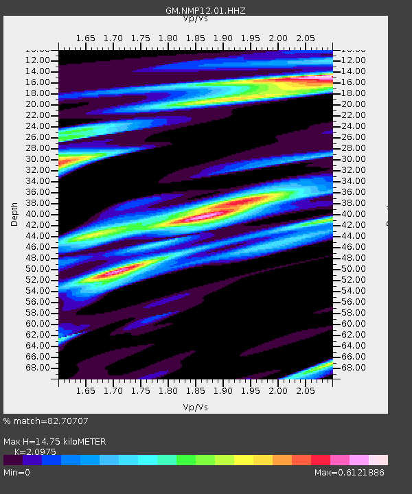
| Estimated Moho Depth: |
14.75 km |
| Estimated Crust Vp/Vs: |
2.10 |
| Assumed Crust Vp: |
6.129 km/s |
| Estimated Crust Vs: |
2.922 km/s |
| Estimated Crust Poisson's Ratio: |
0.35 |
|
| Radial Match: |
82.70707 % |
| Radial Bump: |
400 |
| Transverse Match: |
66.25149 % |
| Transverse Bump: |
400 |
| SOD ConfigId: |
27527651 |
| Insert Time: |
2022-06-09 15:56:09.618 +0000 |
| GWidth: |
2.5 |
| Max Bumps: |
400 |
| Tol: |
0.001 |
|

Signal To Noise
| Channel | StoN | STA | LTA |
| GM:NMP12:01:HHZ:20220526T15:51:03.465027Z | 4.3507977 | 1.143999E-6 | 2.629401E-7 |
| GM:NMP12:01:HHN:20220526T15:51:03.465027Z | 1.0305339 | 1.7848738E-7 | 1.7319896E-7 |
| GM:NMP12:01:HHE:20220526T15:51:03.465027Z | 1.3573956 | 2.3753576E-7 | 1.7499376E-7 |
| Arrivals |
| Ps | 2.7 SECOND |
| PpPs | 7.3 SECOND |
| PsPs/PpSs | 10 SECOND |


