You are here: Home > Network List > GM - US Geological Survey Networks Stations List
> Station NMP51 New Mexico Permian - Site# W5S1 > Earthquake Result Viewer
NMP51 New Mexico Permian - Site# W5S1 - Earthquake Result Viewer
| Earthquake location: |
Southeast Of Loyalty Islands |
| Earthquake latitude/longitude: |
-22.9/172.0 |
| Earthquake time(UTC): |
2022/05/26 (146) 15:38:03 GMT |
| Earthquake Depth: |
10 km |
| Earthquake Magnitude: |
6.9 Mi |
| Earthquake Catalog/Contributor: |
NEIC PDE/at |
|
| Network: |
GM US Geological Survey Networks |
| Station: |
NMP51 New Mexico Permian - Site# W5S1 |
| Lat/Lon: |
32.00 N/103.42 W |
| Elevation: |
975 m |
|
| Distance: |
97.5 deg |
| Az: |
58.544 deg |
| Baz: |
247.798 deg |
| Ray Param: |
0.040207077 |
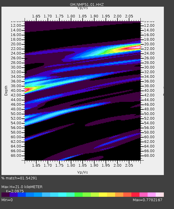
| Estimated Moho Depth: |
21.0 km |
| Estimated Crust Vp/Vs: |
2.10 |
| Assumed Crust Vp: |
6.129 km/s |
| Estimated Crust Vs: |
2.922 km/s |
| Estimated Crust Poisson's Ratio: |
0.35 |
|
| Radial Match: |
81.54291 % |
| Radial Bump: |
400 |
| Transverse Match: |
58.696945 % |
| Transverse Bump: |
400 |
| SOD ConfigId: |
27527651 |
| Insert Time: |
2022-06-09 15:56:16.854 +0000 |
| GWidth: |
2.5 |
| Max Bumps: |
400 |
| Tol: |
0.001 |
|

Signal To Noise
| Channel | StoN | STA | LTA |
| GM:NMP51:01:HHZ:20220526T15:51:05.11499Z | 5.5601935 | 1.0333038E-6 | 1.8583953E-7 |
| GM:NMP51:01:HHN:20220526T15:51:05.11499Z | 1.2389895 | 1.4640953E-7 | 1.1816851E-7 |
| GM:NMP51:01:HHE:20220526T15:51:05.11499Z | 2.1789837 | 2.709146E-7 | 1.2433071E-7 |
| Arrivals |
| Ps | 3.8 SECOND |
| PpPs | 10 SECOND |
| PsPs/PpSs | 14 SECOND |


