You are here: Home > Network List > XM99 - Rio Grande Seismic Transect Stations List
> Station NM16 NewMexico16 > Earthquake Result Viewer
NM16 NewMexico16 - Earthquake Result Viewer
| Earthquake location: |
Southern Bolivia |
| Earthquake latitude/longitude: |
-20.9/-67.3 |
| Earthquake time(UTC): |
1999/09/15 (258) 03:01:24 GMT |
| Earthquake Depth: |
218 km |
| Earthquake Magnitude: |
6.0 MB, 6.4 MW, 6.4 MW |
| Earthquake Catalog/Contributor: |
WHDF/NEIC |
|
| Network: |
XM Rio Grande Seismic Transect |
| Station: |
NM16 NewMexico16 |
| Lat/Lon: |
33.17 N/105.13 W |
| Elevation: |
1625 m |
|
| Distance: |
64.8 deg |
| Az: |
325.339 deg |
| Baz: |
140.663 deg |
| Ray Param: |
0.058020756 |
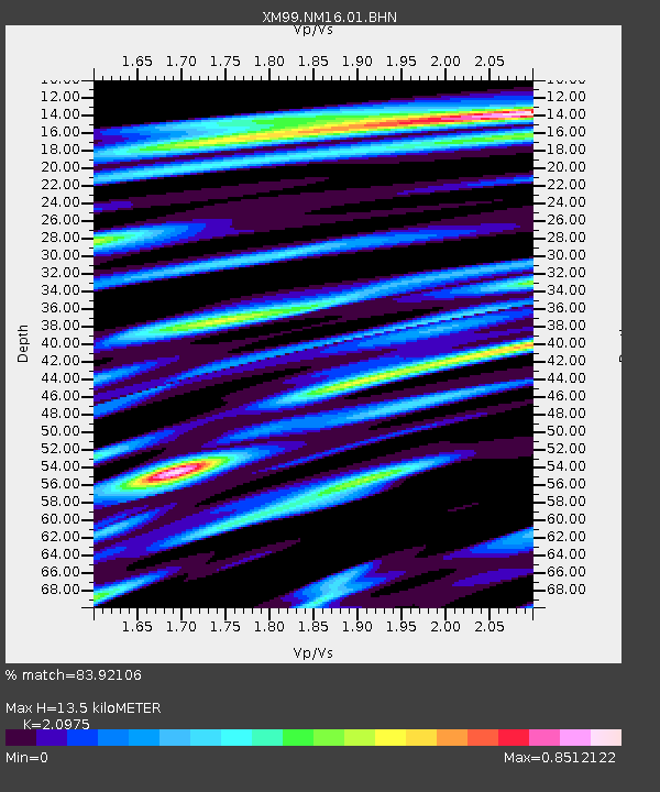
| Estimated Moho Depth: |
13.5 km |
| Estimated Crust Vp/Vs: |
2.10 |
| Assumed Crust Vp: |
6.232 km/s |
| Estimated Crust Vs: |
2.971 km/s |
| Estimated Crust Poisson's Ratio: |
0.35 |
|
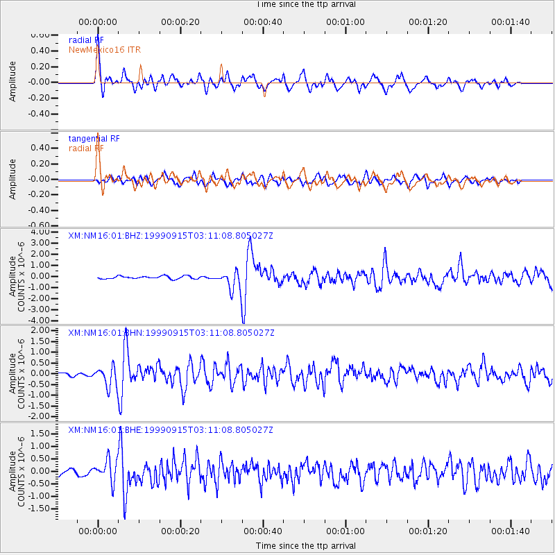
| Radial Match: |
83.92106 % |
| Radial Bump: |
400 |
| Transverse Match: |
69.126076 % |
| Transverse Bump: |
400 |
| SOD ConfigId: |
27569 |
| Insert Time: |
2010-02-26 17:26:18.982 +0000 |
| GWidth: |
2.5 |
| Max Bumps: |
400 |
| Tol: |
0.001 |
|
Signal To Noise
| Channel | StoN | STA | LTA |
| XM:NM16:01:BHN:19990915T03:11:08.805027Z | 6.3552322 | 4.8592153E-7 | 7.6460076E-8 |
| XM:NM16:01:BHE:19990915T03:11:08.805027Z | 3.523764 | 4.6088064E-7 | 1.3079215E-7 |
| XM:NM16:01:BHZ:19990915T03:11:08.805027Z | 7.508696 | 9.249496E-7 | 1.2318378E-7 |
| Arrivals |
| Ps | 2.5 SECOND |
| PpPs | 6.5 SECOND |
| PsPs/PpSs | 9.0 SECOND |


