You are here: Home > Network List > IU - Global Seismograph Network (GSN - IRIS/USGS) Stations List
> Station SLBS Sierra la Laguna Baja California Sur, Mexico > Earthquake Result Viewer
SLBS Sierra la Laguna Baja California Sur, Mexico - Earthquake Result Viewer
| Earthquake location: |
Southeast Of Loyalty Islands |
| Earthquake latitude/longitude: |
-22.9/172.0 |
| Earthquake time(UTC): |
2022/05/26 (146) 15:38:03 GMT |
| Earthquake Depth: |
10 km |
| Earthquake Magnitude: |
6.9 Mi |
| Earthquake Catalog/Contributor: |
NEIC PDE/at |
|
| Network: |
IU Global Seismograph Network (GSN - IRIS/USGS) |
| Station: |
SLBS Sierra la Laguna Baja California Sur, Mexico |
| Lat/Lon: |
23.69 N/109.94 W |
| Elevation: |
825 m |
|
| Distance: |
88.8 deg |
| Az: |
63.778 deg |
| Baz: |
244.467 deg |
| Ray Param: |
0.042293422 |
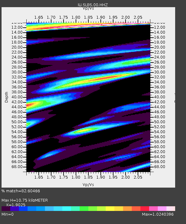
| Estimated Moho Depth: |
10.75 km |
| Estimated Crust Vp/Vs: |
1.90 |
| Assumed Crust Vp: |
6.183 km/s |
| Estimated Crust Vs: |
3.25 km/s |
| Estimated Crust Poisson's Ratio: |
0.31 |
|
| Radial Match: |
82.60466 % |
| Radial Bump: |
400 |
| Transverse Match: |
76.14731 % |
| Transverse Bump: |
400 |
| SOD ConfigId: |
27527651 |
| Insert Time: |
2022-06-09 15:58:04.251 +0000 |
| GWidth: |
2.5 |
| Max Bumps: |
400 |
| Tol: |
0.001 |
|
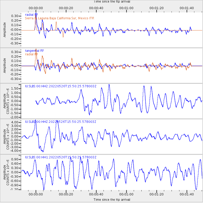
Signal To Noise
| Channel | StoN | STA | LTA |
| IU:SLBS:00:HHZ:20220526T15:50:25.578003Z | 8.504813 | 3.0601523E-6 | 3.5981415E-7 |
| IU:SLBS:00:HH1:20220526T15:50:25.578003Z | 2.2544968 | 4.761426E-7 | 2.1119683E-7 |
| IU:SLBS:00:HH2:20220526T15:50:25.578003Z | 3.7181199 | 8.5706057E-7 | 2.3050913E-7 |
| Arrivals |
| Ps | 1.6 SECOND |
| PpPs | 5.0 SECOND |
| PsPs/PpSs | 6.6 SECOND |


