You are here: Home > Network List > IW - Intermountain West Stations List
> Station FLWY Flagg Ranch, Wyoming, USA > Earthquake Result Viewer
FLWY Flagg Ranch, Wyoming, USA - Earthquake Result Viewer
| Earthquake location: |
Southeast Of Loyalty Islands |
| Earthquake latitude/longitude: |
-22.9/172.0 |
| Earthquake time(UTC): |
2022/05/26 (146) 15:38:03 GMT |
| Earthquake Depth: |
10 km |
| Earthquake Magnitude: |
6.9 Mi |
| Earthquake Catalog/Contributor: |
NEIC PDE/at |
|
| Network: |
IW Intermountain West |
| Station: |
FLWY Flagg Ranch, Wyoming, USA |
| Lat/Lon: |
44.08 N/110.70 W |
| Elevation: |
2078 m |
|
| Distance: |
97.0 deg |
| Az: |
45.1 deg |
| Baz: |
245.005 deg |
| Ray Param: |
0.040346205 |
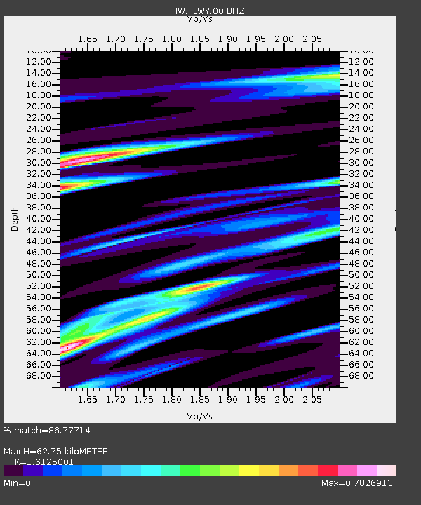
| Estimated Moho Depth: |
62.75 km |
| Estimated Crust Vp/Vs: |
1.61 |
| Assumed Crust Vp: |
6.35 km/s |
| Estimated Crust Vs: |
3.938 km/s |
| Estimated Crust Poisson's Ratio: |
0.19 |
|
| Radial Match: |
86.77714 % |
| Radial Bump: |
400 |
| Transverse Match: |
64.0099 % |
| Transverse Bump: |
400 |
| SOD ConfigId: |
27527651 |
| Insert Time: |
2022-06-09 15:58:11.314 +0000 |
| GWidth: |
2.5 |
| Max Bumps: |
400 |
| Tol: |
0.001 |
|

Signal To Noise
| Channel | StoN | STA | LTA |
| IW:FLWY:00:BHZ:20220526T15:51:03.099976Z | 15.817971 | 1.1109125E-6 | 7.023104E-8 |
| IW:FLWY:00:BH1:20220526T15:51:03.099976Z | 2.4149053 | 1.7577753E-7 | 7.278858E-8 |
| IW:FLWY:00:BH2:20220526T15:51:03.099976Z | 2.8333006 | 3.1763366E-7 | 1.12107294E-7 |
| Arrivals |
| Ps | 6.2 SECOND |
| PpPs | 25 SECOND |
| PsPs/PpSs | 31 SECOND |


