You are here: Home > Network List > NN - Western Great Basin/Eastern Sierra Nevada Stations List
> Station PAH Pah Rah Range, Nevada w84gm > Earthquake Result Viewer
PAH Pah Rah Range, Nevada w84gm - Earthquake Result Viewer
| Earthquake location: |
Southeast Of Loyalty Islands |
| Earthquake latitude/longitude: |
-22.9/172.0 |
| Earthquake time(UTC): |
2022/05/26 (146) 15:38:03 GMT |
| Earthquake Depth: |
10 km |
| Earthquake Magnitude: |
6.9 Mi |
| Earthquake Catalog/Contributor: |
NEIC PDE/at |
|
| Network: |
NN Western Great Basin/Eastern Sierra Nevada |
| Station: |
PAH Pah Rah Range, Nevada w84gm |
| Lat/Lon: |
39.71 N/119.39 W |
| Elevation: |
1520 m |
|
| Distance: |
89.2 deg |
| Az: |
45.917 deg |
| Baz: |
239.171 deg |
| Ray Param: |
0.041995313 |
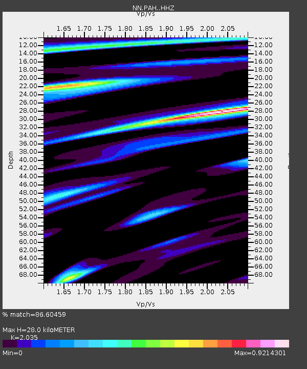
| Estimated Moho Depth: |
28.0 km |
| Estimated Crust Vp/Vs: |
2.04 |
| Assumed Crust Vp: |
6.279 km/s |
| Estimated Crust Vs: |
3.085 km/s |
| Estimated Crust Poisson's Ratio: |
0.34 |
|
| Radial Match: |
86.60459 % |
| Radial Bump: |
376 |
| Transverse Match: |
66.090866 % |
| Transverse Bump: |
400 |
| SOD ConfigId: |
27527651 |
| Insert Time: |
2022-06-09 15:59:40.245 +0000 |
| GWidth: |
2.5 |
| Max Bumps: |
400 |
| Tol: |
0.001 |
|

Signal To Noise
| Channel | StoN | STA | LTA |
| NN:PAH: :HHZ:20220526T15:50:27.52301Z | 43.267918 | 2.7944475E-6 | 6.4584746E-8 |
| NN:PAH: :HHN:20220526T15:50:27.52301Z | 9.6004925 | 4.654866E-7 | 4.8485703E-8 |
| NN:PAH: :HHE:20220526T15:50:27.52301Z | 10.451112 | 8.090872E-7 | 7.741638E-8 |
| Arrivals |
| Ps | 4.7 SECOND |
| PpPs | 13 SECOND |
| PsPs/PpSs | 18 SECOND |


