You are here: Home > Network List > TM - Thai Seismic Monitoring Network Stations List
> Station PANO PANO staion > Earthquake Result Viewer
PANO PANO staion - Earthquake Result Viewer
| Earthquake location: |
Southeast Of Loyalty Islands |
| Earthquake latitude/longitude: |
-22.9/172.0 |
| Earthquake time(UTC): |
2022/05/26 (146) 15:38:03 GMT |
| Earthquake Depth: |
10 km |
| Earthquake Magnitude: |
6.9 Mi |
| Earthquake Catalog/Contributor: |
NEIC PDE/at |
|
| Network: |
TM Thai Seismic Monitoring Network |
| Station: |
PANO PANO staion |
| Lat/Lon: |
17.15 N/104.61 E |
| Elevation: |
136 m |
|
| Distance: |
77.0 deg |
| Az: |
295.047 deg |
| Baz: |
119.101 deg |
| Ray Param: |
0.050643057 |
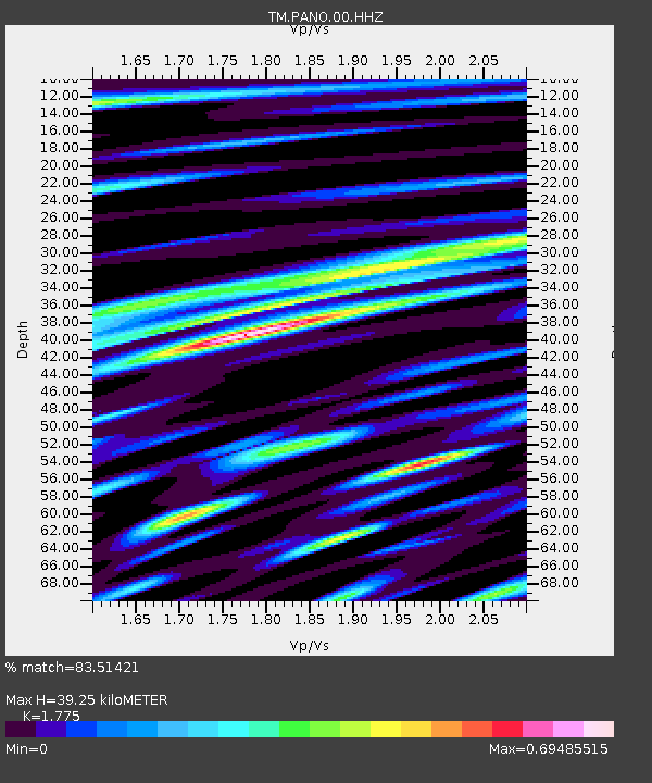
| Estimated Moho Depth: |
39.25 km |
| Estimated Crust Vp/Vs: |
1.77 |
| Assumed Crust Vp: |
6.498 km/s |
| Estimated Crust Vs: |
3.661 km/s |
| Estimated Crust Poisson's Ratio: |
0.27 |
|
| Radial Match: |
83.51421 % |
| Radial Bump: |
400 |
| Transverse Match: |
77.818985 % |
| Transverse Bump: |
400 |
| SOD ConfigId: |
27527651 |
| Insert Time: |
2022-06-09 16:02:46.623 +0000 |
| GWidth: |
2.5 |
| Max Bumps: |
400 |
| Tol: |
0.001 |
|

Signal To Noise
| Channel | StoN | STA | LTA |
| TM:PANO:00:HHZ:20220526T15:49:24.299988Z | 13.889096 | 1.1855553E-7 | 8.535871E-9 |
| TM:PANO:00:HHN:20220526T15:49:24.299988Z | 1.7615027 | 1.5652901E-8 | 8.886106E-9 |
| TM:PANO:00:HHE:20220526T15:49:24.299988Z | 2.6917002 | 3.3440536E-8 | 1.2423573E-8 |
| Arrivals |
| Ps | 4.8 SECOND |
| PpPs | 16 SECOND |
| PsPs/PpSs | 21 SECOND |


