You are here: Home > Network List > XM99 - Rio Grande Seismic Transect Stations List
> Station NM16 NewMexico16 > Earthquake Result Viewer
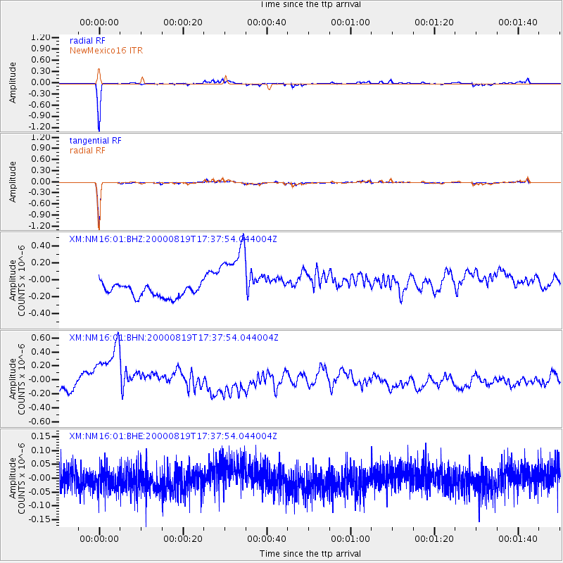
NM16 NewMexico16 - Earthquake Result Viewer
*The percent match for this event was below the threshold and hence no stack was calculated.
| Earthquake location: |
Kuril Islands |
| Earthquake latitude/longitude: |
43.8/147.2 |
| Earthquake time(UTC): |
2000/08/19 (232) 17:26:27 GMT |
| Earthquake Depth: |
62 km |
| Earthquake Magnitude: |
6.0 MB, 5.8 MW, 5.7 MW |
| Earthquake Catalog/Contributor: |
WHDF/NEIC |
|
| Network: |
XM Rio Grande Seismic Transect |
| Station: |
NM16 NewMexico16 |
| Lat/Lon: |
33.17 N/105.13 W |
| Elevation: |
1625 m |
|
| Distance: |
79.0 deg |
| Az: |
54.484 deg |
| Baz: |
315.369 deg |
| Ray Param: |
$rayparam |
*The percent match for this event was below the threshold and hence was not used in the summary stack. |
|
| Radial Match: |
92.51782 % |
| Radial Bump: |
206 |
| Transverse Match: |
95.38875 % |
| Transverse Bump: |
149 |
| SOD ConfigId: |
3744 |
| Insert Time: |
2010-02-26 17:26:23.743 +0000 |
| GWidth: |
2.5 |
| Max Bumps: |
400 |
| Tol: |
0.001 |
|
Signal To Noise
| Channel | StoN | STA | LTA |
| XM:NM16:01:BHN:20000819T17:37:54.044004Z | 6.6283503 | 5.4845293E-7 | 8.2743504E-8 |
| XM:NM16:01:BHE:20000819T17:37:54.044004Z | 0.99332565 | 4.406568E-8 | 4.4361766E-8 |
| XM:NM16:01:BHZ:20000819T17:37:54.044004Z | 5.905542 | 4.211317E-7 | 7.131127E-8 |
| Arrivals |
| Ps | |
| PpPs | |
| PsPs/PpSs | |


