You are here: Home > Network List > UU - University of Utah Regional Network Stations List
> Station CCUT Cedar City, UT, USA > Earthquake Result Viewer
CCUT Cedar City, UT, USA - Earthquake Result Viewer
| Earthquake location: |
Southeast Of Loyalty Islands |
| Earthquake latitude/longitude: |
-22.9/172.0 |
| Earthquake time(UTC): |
2022/05/26 (146) 15:38:03 GMT |
| Earthquake Depth: |
10 km |
| Earthquake Magnitude: |
6.9 Mi |
| Earthquake Catalog/Contributor: |
NEIC PDE/at |
|
| Network: |
UU University of Utah Regional Network |
| Station: |
CCUT Cedar City, UT, USA |
| Lat/Lon: |
37.55 N/113.36 W |
| Elevation: |
2127 m |
|
| Distance: |
92.3 deg |
| Az: |
50.087 deg |
| Baz: |
242.861 deg |
| Ray Param: |
0.041476626 |
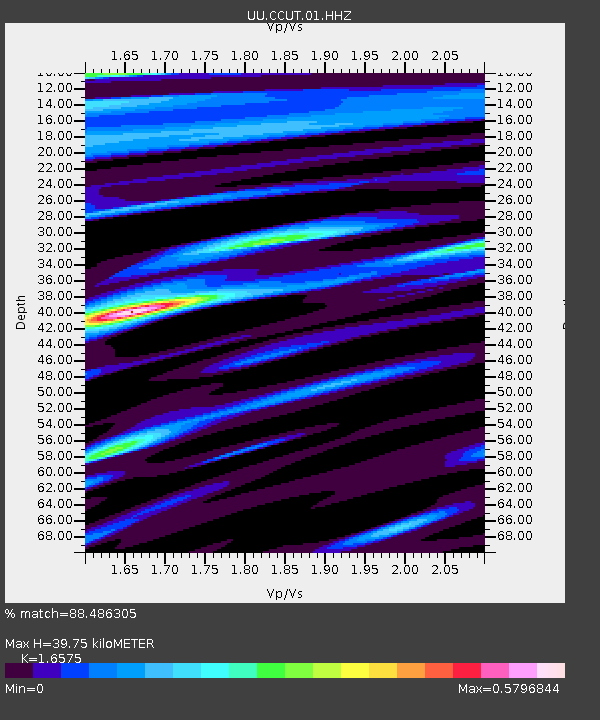
| Estimated Moho Depth: |
39.75 km |
| Estimated Crust Vp/Vs: |
1.66 |
| Assumed Crust Vp: |
6.194 km/s |
| Estimated Crust Vs: |
3.737 km/s |
| Estimated Crust Poisson's Ratio: |
0.21 |
|
| Radial Match: |
88.486305 % |
| Radial Bump: |
397 |
| Transverse Match: |
65.844284 % |
| Transverse Bump: |
400 |
| SOD ConfigId: |
27527651 |
| Insert Time: |
2022-06-09 16:05:14.055 +0000 |
| GWidth: |
2.5 |
| Max Bumps: |
400 |
| Tol: |
0.001 |
|

Signal To Noise
| Channel | StoN | STA | LTA |
| UU:CCUT:01:HHZ:20220526T15:50:41.780029Z | 19.641201 | 1.2047578E-6 | 6.13383E-8 |
| UU:CCUT:01:HHN:20220526T15:50:41.780029Z | 2.078915 | 1.3000106E-7 | 6.2533125E-8 |
| UU:CCUT:01:HHE:20220526T15:50:41.780029Z | 5.9286256 | 3.0101148E-7 | 5.0772556E-8 |
| Arrivals |
| Ps | 4.3 SECOND |
| PpPs | 17 SECOND |
| PsPs/PpSs | 21 SECOND |


