You are here: Home > Network List > UU - University of Utah Regional Network Stations List
> Station FOR7 FORGE > Earthquake Result Viewer
FOR7 FORGE - Earthquake Result Viewer
| Earthquake location: |
Southeast Of Loyalty Islands |
| Earthquake latitude/longitude: |
-22.9/172.0 |
| Earthquake time(UTC): |
2022/05/26 (146) 15:38:03 GMT |
| Earthquake Depth: |
10 km |
| Earthquake Magnitude: |
6.9 Mi |
| Earthquake Catalog/Contributor: |
NEIC PDE/at |
|
| Network: |
UU University of Utah Regional Network |
| Station: |
FOR7 FORGE |
| Lat/Lon: |
38.42 N/112.85 W |
| Elevation: |
1964 m |
|
| Distance: |
93.1 deg |
| Az: |
49.495 deg |
| Baz: |
243.202 deg |
| Ray Param: |
0.041339826 |
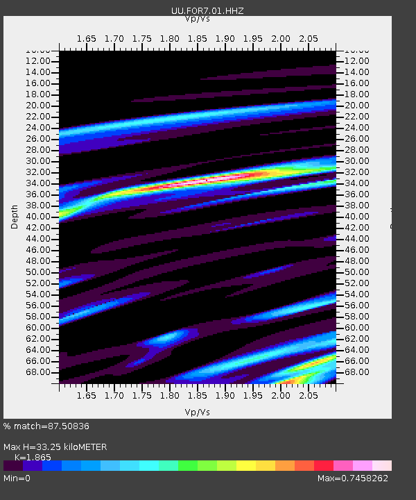
| Estimated Moho Depth: |
33.25 km |
| Estimated Crust Vp/Vs: |
1.87 |
| Assumed Crust Vp: |
6.276 km/s |
| Estimated Crust Vs: |
3.365 km/s |
| Estimated Crust Poisson's Ratio: |
0.30 |
|
| Radial Match: |
87.50836 % |
| Radial Bump: |
400 |
| Transverse Match: |
76.62136 % |
| Transverse Bump: |
400 |
| SOD ConfigId: |
27527651 |
| Insert Time: |
2022-06-09 16:05:33.213 +0000 |
| GWidth: |
2.5 |
| Max Bumps: |
400 |
| Tol: |
0.001 |
|

Signal To Noise
| Channel | StoN | STA | LTA |
| UU:FOR7:01:HHZ:20220526T15:50:45.23999Z | 19.901194 | 1.7167819E-6 | 8.6265274E-8 |
| UU:FOR7:01:HHN:20220526T15:50:45.23999Z | 2.8876858 | 2.7616957E-7 | 9.5636985E-8 |
| UU:FOR7:01:HHE:20220526T15:50:45.23999Z | 7.1944885 | 6.032913E-7 | 8.385465E-8 |
| Arrivals |
| Ps | 4.7 SECOND |
| PpPs | 15 SECOND |
| PsPs/PpSs | 20 SECOND |


