You are here: Home > Network List > UW - Pacific Northwest Regional Seismic Network Stations List
> Station DOTY Weyerhaeuser Tree Farm, Grays Harbor County, WA, USA > Earthquake Result Viewer
DOTY Weyerhaeuser Tree Farm, Grays Harbor County, WA, USA - Earthquake Result Viewer
| Earthquake location: |
Southeast Of Loyalty Islands |
| Earthquake latitude/longitude: |
-22.9/172.0 |
| Earthquake time(UTC): |
2022/05/26 (146) 15:38:03 GMT |
| Earthquake Depth: |
10 km |
| Earthquake Magnitude: |
6.9 Mi |
| Earthquake Catalog/Contributor: |
NEIC PDE/at |
|
| Network: |
UW Pacific Northwest Regional Seismic Network |
| Station: |
DOTY Weyerhaeuser Tree Farm, Grays Harbor County, WA, USA |
| Lat/Lon: |
46.70 N/123.37 W |
| Elevation: |
430 m |
|
| Distance: |
90.5 deg |
| Az: |
38.452 deg |
| Baz: |
236.432 deg |
| Ray Param: |
0.04169927 |
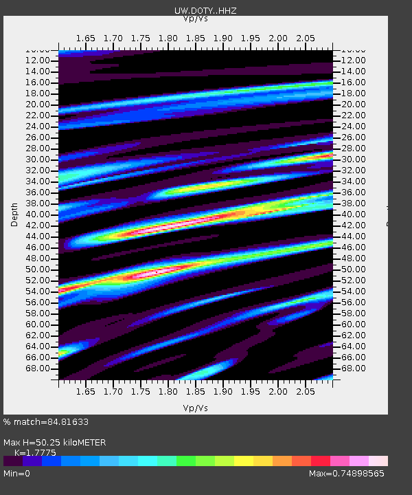
| Estimated Moho Depth: |
50.25 km |
| Estimated Crust Vp/Vs: |
1.78 |
| Assumed Crust Vp: |
6.566 km/s |
| Estimated Crust Vs: |
3.694 km/s |
| Estimated Crust Poisson's Ratio: |
0.27 |
|
| Radial Match: |
84.81633 % |
| Radial Bump: |
400 |
| Transverse Match: |
77.31608 % |
| Transverse Bump: |
400 |
| SOD ConfigId: |
27527651 |
| Insert Time: |
2022-06-09 16:06:06.290 +0000 |
| GWidth: |
2.5 |
| Max Bumps: |
400 |
| Tol: |
0.001 |
|

Signal To Noise
| Channel | StoN | STA | LTA |
| UW:DOTY: :HHZ:20220526T15:50:33.359985Z | 23.552454 | 2.3644295E-6 | 1.0038994E-7 |
| UW:DOTY: :HHN:20220526T15:50:33.359985Z | 2.37424 | 3.9936853E-7 | 1.68209E-7 |
| UW:DOTY: :HHE:20220526T15:50:33.359985Z | 5.637106 | 8.260316E-7 | 1.465347E-7 |
| Arrivals |
| Ps | 6.1 SECOND |
| PpPs | 21 SECOND |
| PsPs/PpSs | 27 SECOND |


