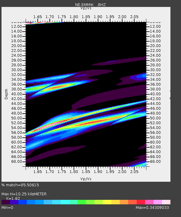
EMMW Machias, ME - Earthquake Result Viewer

Earthquake location: Near East Coast Of Honshu, Japan
Earthquake latitude/longitude: 36.2/141.5
Earthquake time(UTC): 2008/05/07 (128) 16:45:20 GMT
Earthquake Depth: 39 km
Earthquake Magnitude: 6.1 MB, 6.7 MS, 6.8 MW, 6.8 MW
Earthquake Catalog/Contributor: WHDF/NEIC
Network: NE New England Seismic Network
Station: EMMW Machias, ME
Lat/Lon: 44.71 N/67.46 W
Elevation: 34 m
Distance: 95.3 deg
Az: 20.301 deg
Baz: 336.81 deg
Ray Param: 0.04079123
Estimated Moho Depth: 10.25 km
Estimated Crust Vp/Vs: 1.62
Assumed Crust Vp: 6.419 km/s
Estimated Crust Vs: 3.962 km/s
Estimated Crust Poisson's Ratio: 0.19
Radial Match: 85.50615 %
Radial Bump: 384
Transverse Match: 70.00226 %
Transverse Bump: 349
SOD ConfigId: 2504
Insert Time: 2010-03-09 20:21:38.007 +0000
GWidth: 2.5
Max Bumps: 400
Tol: 0.001

Signal To Noise

ChannelStoNSTALTA
NE:EMMW: :BHZ:20080507T16:58:14.709006Z2.28029233.2557405E-61.4277733E-6
NE:EMMW: :BHN:20080507T16:58:14.709006Z0.871381347.6180356E-78.7424814E-7
NE:EMMW: :BHE:20080507T16:58:14.709006Z0.87624554.2113047E-74.8060787E-7
Arrivals
Ps1.0 SECOND
PpPs4.1 SECOND
PsPs/PpSs5.1 SECOND